


Plan ahead when hiking this Winter
Plan ahead when hiking this Winter
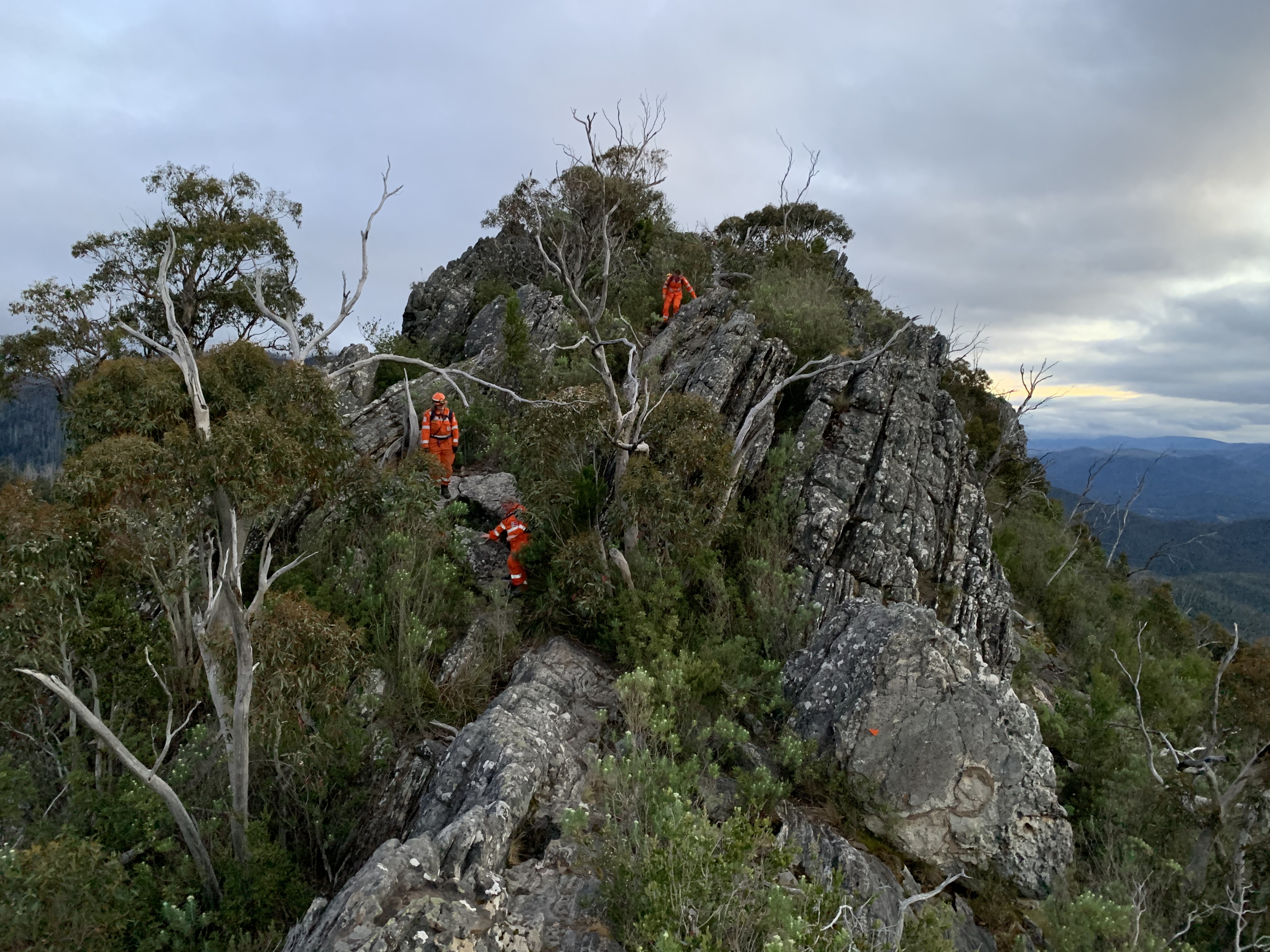
VICSES volunteers undertake a search and rescue operation at Cathedral Range Park, 2023 [credit: VICSES]
This winter, the Victoria State Emergency Service (VICSES) and Parks Victoria (PV) is urging visitors to state parks to plan in advance for adverse conditions, and to remain vigilant when bushwalking or hiking.
As we mark the first day of winter, and the days grow shorter, hikers can be caught out by early nightfall.
Daylight hours are cut even shorter by the high ridges at locations like Lerderderg or Werribee Gorge, which increases the risk of serious injury from slips and falls. Wet conditions and early dusk increase the risk of serious injury from slips, falls, and hypothermia.
Parts of the Cathedral Range, Lerderderg, and Werribee Gorge, are well known to local VICSES and PV crews as the setting for labour-intensive, time-consuming rescues, Their natural beauty and short driving distance from Melbourne have made them hotspots.
The walking trails at Cathedral Range State Park, which popular on social media for its jagged peaks and sweeping vistas, have been the subject of a five year renovation by Parks Victoria rangers and local VICSES volunteers.
The installation of the new Emergency Services Telecommunications Authority (ESTA) markers is the biggest milestone for the PV/VICSES crew since 2019, when the improved trail header and destination signage were erected throughout Cathedral Range State Park.
Furthermore, by implementing steep - and high angle - rope rescue capability at the local VICSES unit has been important addition to the unit and to the park as a visitor site. This new skill set represents a targeted upgrade to our volunteer’s preparedness and response capability, and is of benefit to the park, and to local communities.
In the three years prior to 2020 the local VICSES team assisted 70 people in the park, but since the signage upgrade less than 20 people have been seriously lost or injured.
Developing good local relationships between both agencies was critical to establishing a strong level of support and trust between the teams. Parks Victoria leverage VICSES expertise in SAR to inform their management plans and activities, and the benefits go both ways; with VICSES personnel able to call on local PV Rangers for advice and help.
It is this relationship that drives improvements at the park itself, and to the service VICSES provides to the community, and Victoria Police.
Search and rescue operations require, on average, eight VICSES volunteers in three vehicles, working for around four hours, amounting to thirty-two hours of volunteer time for each rescue. This does not including the work undertaken by Parks Victoria, Ambulance Victoria, and Victoria Police Search and Rescue personnel.
If you were out hiking, camping or bike-riding and you had to call triple zero in an emergency, would you know how to tell the operator exactly where you are?
Before you head off on a hike, take a moment to plan ahead:
- Know your limitations – consider the degree of difficulty of any walks or hikes you are taking and ensure you don’t overdo it.
- Pack a map and a compass, or know your route via GPS, and know any common location names.
- Become familiar with emergency markers located along bushwalking tracks. They are designed to pinpoint your exact location during an emergency in public open spaces or a hard to define places. They display three letters and three numbers which gives an exact location of where the markers are.
- Ensure you keep away from hazardous trees in the wind.
- Take plenty of water and some food.
- Wear appropriate footwear and clothes for the conditions.
- Have communications equipment that will work where you are going – like a satellite phone if you’re going for extended periods across low coverage areas. Consider if you’ll need radio backup, a Personal Locator Beacon, a copy of any important phone numbers, a phone charger, battery pack or other communications supplies.
- If visiting national parks or walking tracks, check with Parks Victoria via parkweb.vic.gov.au ahead of time for closures.
- When planning your walk, use trusted sources of information like the Parks Victoria website. Visitor Guides on park specific pages have maps and information about walking difficulty and estimated duration, based on the Australian Walking Track Grading System. There are also important and timely updates on park or track closures.
Quotes attributable to VICSES Marysville Unit, Controller, Josephine Hunter:
"After many years of hard work, it's been incredibly rewarding to see us reach the milestone of Emergency Services Telecommunications Authority (ESTA) markers being installed, and most importantly being able to confidently say we're seeing the number of avoidable Search and Rescue (SAR) incidents in Cathedral Range State Park dropping."
"Being out in the park and seeing visitors utilising the improved signage and trail markers, and making better decisions at key points, provides a real feeling of satisfaction that we've 'got it right' so far.”
“Better signage, trail markings - including ESTA markers that help pinpoint your location - have all made a difference. We have also worked with local tourism operators to make sure visitors are getting all the information they need.”
Quotes attributable to Parks Victoria, Area Chief Ranger, Andrew Sawicki:
“It always pays to be prepared for a hike, at any time but particularly in the autumn and winter – even if a walk is close to the city, like the Cathedral Range or Lerderderg. We’re proud of the work we have done with SES and the local community to improve safety at Cathedral.”
“There’s lots of great information available on the Parks Victoria website that will help you keep safe wherever you are planning to go.”
“The Cathedral Range is a dramatic challenge for walkers and shouldn’t be underestimated. The tops of the ranges are very exposed and if you are not properly prepared bad things can happen. In 2019 we had a spate of rescues – four over three days at one point.”
“The majority of our work in the park was for walkers who didn’t have a headlamp and became lost after dark. The tracks in the park don’t appear long on paper, but they are tricky, and it takes a long time to travel small distances. People were caught out because they were unprepared."


