City of Greater Bendigo

Flood information for the City of Greater Bendigo, encompassing local flood guides and a Municipal Flood Emergency Plan. 

On this page:


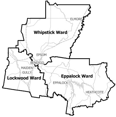
Greater Bendigo municipal map
   Greater Bendigo municipal map.

City of Greater Bendigo has a long history of storm and flash flooding with varying impact, from small urban pockets to whole suburbs and outlying areas affected.

The lead time to respond to a storm and flash flooding events may be limited. All households and businesses at risk of flooding should develop an emergency plan and be aware of their flood risk.

The Golden Square and Kangaroo Flat area have a history of flooding and is especially prone to flash flooding with recorded floods occurring since settlement in 1850.

  • The 1857 flood is one of the largest on record and occurred after 82mm of rain fell in under 24 hours, causing significant flooding along the Bendigo and Back Creeks.

  • In November 1933 the Bendigo Creek overflowed its banks at Kangaroo Flat flooding 100 houses in High street and washing away a bridge in Alder Street.

  • In 1951, Bendigo received 80.2mm of rain over two days resulting in half a mile of railway line washed away. In Kangaroo Flat the water was waist deep.

  • In January 1996 heavy thunderstorms resulted in many shops and residences flooding throughout Kangaroo Flat

  • During March 2010 approximately 80mm was recorded in 3 days with a maximum burst of around 40mm in 2 hours

  • In September 2010 around 80mm of rain fell in 1 day with 40mm over approximately 10 hours

  • The February 2011 flood saw a total of 100mm of rain recorded over 3 days with approximately 50mm in a 5 hour burst.

Are you at risk of flood?

Golden square flood map
  Click to enlarge.

Many properties in Bendigo are located close to the city’s natural waterways and floodplains,
leaving a number of properties and people at risk of the effects of flooding from overflows of the waterways.

It is important to assess the risk of flooding around your property to see where runoff water may come from, where it will impact your home, and where the water will go once on your property.

Even if your property isn’t close to a waterway it could still be at risk of flooding. Recent urban development has changed the natural flow of the excess water runoff. It is common for properties in these areas to be flooded from water travelling down streets and driveways.

If you live or work close to a creek, river or low-lying area you may be at risk. Whether you are a household or a business, it is important that you are aware of the risks, be prepared and have your emergency plans ready for when an emergency occurs.

The North Central Catchment Management Authority (NCCMA) in partnership with the City of Greater Bendigo Council has undertaken a flood study for the urban areas of Bendigo. The Bendigo Urban Flood study provides detailed flood information for a range of flood events, assists future land use planning development decisions, and helps authorities and the community to prepare for and respond to flood events.

This was implemented into the Greater Bendigo Planning Scheme, with a Flooding Overlay that is designed to:

  • Minimise the effects of overland flows and flooding on new buildings.

  • Ensure new developments don’t adversely affect existing properties.

NCCMA has developed an online mapping tool called Flood Eye that enables you to obtain a free report that contains flood information specific to your property.

The map to the right shows the potential extent of flooding in a 1% Annual Exceedance Probability (AEP) event. A 1% AEP flood means there is a 1% chance of a flood of this size occurring in any year.

Are you at risk of flood?

Epsom, Huntly and Ascot flood map
  Click to enlarge.


Many properties in Bendigo are located close to the city’s natural waterways and floodplains, leaving a number of properties and people at risk of the effects of flooding from overflows of the waterways.

It is important to assess the risk of flooding around your property to see where runoff water may come from, where it will impact your home, and where the water will go once on your property. Even if your property isn’t close to a waterway it could still be at risk of flooding.

Recent urban development has changed the natural flow of the excess water runoff. It is common for properties in these areas to be flooded from water travelling down streets and driveways.

If you live or work close to a creek, river or low-lying area you may be at risk. Whether you are a household or a business, it is important that you are aware of the risks, be prepared and have your emergency plans ready for when an emergency occurs.

The North Central Catchment Management Authority (NCCMA) in partnership with the City of Greater Bendigo Council has undertaken a flood study for the urban areas of Bendigo. The Bendigo Urban Flood study provides detailed flood information for a range of flood events, assists future land use planning development decisions, and helps authorities and the community to prepare for and respond to flood events. This was implemented into the Greater Bendigo Planning Scheme, with a Flooding Overlay that is designed to:

  • Minimise the effects of overland flows and flooding on new buildings.

  • Ensure new developments don’t adversely affect existing properties.

NCCMA has developed an online mapping tool called Flood Eye that enables you to obtain a free report that contains flood information specific to your property.

The map to the right shows the potential extent of flooding in a 1% Annual Exceedance Probability (AEP) event. A 1% AEP flood means there is a 1% chance of a flood of this size occurring in any year.

Are you at risk of flood?
 

Bendigo, White Hills and Long Gully flood guide
 Click here to enlarge.

Many properties in Bendigo are located close to the city’s natural waterways and floodplains, leaving a number of properties and people at risk of the effects of flooding from overflows of the waterways.

It is important to assess the risk of flooding around your property to see where runoff water may come from, where it will impact your home, and where the water will go once on your property.

Even if your property isn’t close to a waterway it could still be at risk of flooding.

Recent urban development has changed the natural flow of the excess water runoff. It is common for properties in these areas to be flooded from water travelling down streets and driveways.

If you live or work close to a creek, river or low-lying area you may be at risk. Whether you are a household or a business, it is important that you are aware of the risks, be prepared and have your emergency plans ready for when an emergency occurs.

The North Central Catchment Management Authority (NCCMA) in partnership with the City of Greater Bendigo Council has undertaken a flood study for the urban areas of Bendigo. The Bendigo Urban Flood study provides detailed flood information for a range of flood events, assists future land use planning development decisions, and helps authorities and the community to prepare for and respond to flood events.

This was implemented into the Greater Bendigo Planning Scheme, with a Flooding Overlay that is designed to:

  • Minimise the effects of overland flows and flooding on new buildings

  • Ensure new developments don’t adversely affect existing properties

About Flood Guides

Communities can use local flood guides to identify and better understand their local flood risk. They include information about: flood history, how to prepare & respond to floods and who to contact.

Contact Information

For more information, contact the North West Regional Office.
For information on flood warnings, see the VicEmergency website.
Your local Catchment Management Authority: North Central.

Local VICSES Units

Bendigo VICSES Unit :
64 Adam Street,
Bendigo

Marong VICSES Unit :
35 Cathcart Street,
Marong

Heathcote VICSES Unit : 
3-7 Wright Street,
Heathcote

Municipal Flood Emergency Plan (MFEP)

Municipalities can use Municipal Flood Emergency Plans to prepare, respond and recover from flood and storm events.
Greater Bendigo flood and storm Emergency Plan - Updated April, 2018