


Brimbank City Council
Flood information for the Brimbank City Council, including a local flood guide and Municipal Flood Emergency Plan.
Brimbank City Flood History
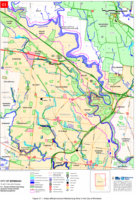
Formed by the junction of Deep Creek and Jacksons Creek on the northern boundary of the Municipality, the Maribyrnong River is the main waterway that passes through Brimbank City. Kororoit Creek is the second major waterway that flows through the Municipality, passing through roughly the southern half of the City.
Water level rises through Brimbank are expected to occur fairly rapidly following a heavy rainfall event. Flooding on Kororoit, Taylors, Steele & Jones Creeks tends to rise and fall quickly.
The lead time to respond to a flood event may be limited. All households and businesses at risk of flooding should develop an emergency plan and beware of their flood risk.
Households and business should refer to the Brimbank City Council Municipal Storm and Flood Emergency Plan for more information.
Are you at risk of flood?
Large severe floods within the Municipality generally occur as a result of a moist warm airflow from northern Australia bringing moderate to heavy rainfall over a period of 12 hours or more following a prolonged period of general rainfall.
The period of general rainfall “wets up” the catchments and (partially) fills both the on-stream dams and the natural floodplain storage. These combine to increase the runoff generated during the subsequent period of heavy rainfall.
Large but less severe floods result from sequences of cold fronts during winter and spring that progressively wet up the catchments and fill the on-stream dams and the natural floodplain storage.
Prolonged moderate to heavy rain leads to major flooding. Water level rises through Brimbank are expected to occur fairly rapidly following a heavy rainfall event, with flooding upstream of Maribyrnong River and possibly taking as little as 3 hours (from Deep Creek) to 6 hours (from Jacksons Creek) to reach the municipality.
Flooding on Kororoit, Taylors, Steele & Jones Creeks tends to rise and fall quickly. Flash Flooding & Overland Flows Short Duration, high intensity rainfall (usually associated with thunderstorms) can also cause localised flooding within the municipality along overland flow paths when the local urban drainage system surcharges.
Such events, which are mainly confined to the summer months, do not generally create widespread flooding since they only last for a short time and affect limited areas. Flooding from these storms occurs with little warning and localised damage can be severe.
High intensity rainfall such as associated with thunderstorms giving average rainfall rates of more than 20mm/hour for an hour or more is likely to lead to flash flooding and / or overland flows, across the urbanised parts of the municipality. Blocked or capacity impaired stormwater drains can also lead to overland flows and associated flooding; the drain surcharges and excess water flows above ground.
Tidal flooding, storm surges, moderate to heavy rainfall, coupled with a high or incoming tide from Port Phillip Bay can exacerbate flooding within the municipality or create areas of flooding in and around the drainage network. (Maribyrnong River is tidal to Solomon’s Ford in Avondale Heights).
Due to the proximity of the Municipality to Port Phillip Bay and its flat terrain, tidal flows from Port Phillip Bay may reduce the capacity of the stormwater drains to discharge runoff back into the bay, while extreme storm events can cause backflow to the point where water surcharges back above ground around the drainage pits and channels.
Brimbank City Council Local Flood Guide
At this time, there are no Local Flood Guides for the Brimbank City Council area. Go to the Plan and stay safe page for information on how you can plan and prepare for emergencies.
Brimbank City Council Flood and Storm Emergency Plan
Municipalities can use Municipal Flood and Storm Emergency Plans to prepare, respond and recover from flood and storm events.
Click the button below to view the Municipal Flood and Strom Emergency Plan.
About Flood Guides
VICSES has developed Local Flood Guides to explain local flood risks for communities at risk. This includes advice for communities on how to prepare and respond to flood events and who to contact in the event of a flood
Contact Information


Local SES Units
- Brimbank VICSES Unit:
Stadium Drive,
Keilor Park, Victoria, 3042
Municipal Flood and Storm Plan
Municipalities can use Municipal Flood and Storm Plans to prepare, respond and recover from flood and storm events.
Brimbank Storm Flood Emergency Plan - Updated December, 2022.
This municipal flood and storm management plan is currently being updated. The revised and updated plan will be available soon.