Cardinia Shire Council

Flood information for the Cardinia Shire Council, encompassing local flood guides for Koo Wee Rup, Pakenham and the Cardinia Shire Council Municipal Flood Emergency Plan.

On this page:

Cardinia Shire Council has a history of flooding (riverine and flash flooding) including a significant

Cardinia Shire Council Municipal Map.
Cardinia Shire Council municipal map.


flood event in June 2012 which impacted the townships of Koo Wee Rup, Bayles, Lang Lang and Modella and vast extents of rural areas resulting in extensive damage.

The lead time to respond to a flood event may be limited. All households and businesses at risk of flooding should develop an emergency plan and beware of their flood risk.
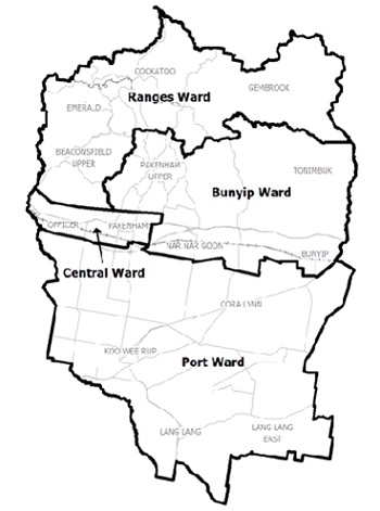
Are you at risk of flood?


Koo Wee Rup flood map
 The potential impact of a major flood in the Koo Wee Rup township.
Click to enlarge.

Cardinia Shire is particularly prone to both inland and coastal flooding. The lowlands of the extensive Koo Wee Rup Swamp originally formed from a depressed basin between the Tyabb Fault and Heath Hill Fault.

Koo Wee Rup has a history of flooding including in 1900, 1901, 1911, 1923, 1934, 1937, 1996, 2011 and 2012. Most of these have resulted from heavy rainfall falling in a short period of time.

While these features extend outside the municipal boundary, the Great Swamp of the lowland is a dominant landscape feature of the region covering over 400 square kilometres with extensive flat areas surrounding the swamp.

Typically the flatter regions became a deposition zone for the larger catchments that drain into the area. This has formed a series of connected wetlands that gave rise to the extensive peat swamps and lowland terrain of today.

Floods typically occur in the low-lying areas of Cardinia Shire, however, flash flooding can occur in other areas as a result of short bursts of heavy rain fall that cannot drain away quickly. Any property on the low side of a street may be at risk. In addition, there is also a risk of flooding caused by drains overflowing. Every flood is different. The map opposite is a guide only and may not be representative of every flood event.

Since records began in 1891, Cardinia Shire has had 15 recorded flood events. The Koo Wee Rup Township has been affected on a number of these occasions. As the area sees slow water movement due to the flat terrain, when flooding occurs, it can last for a number of days or even weeks.

During floods a number of essential services in the Koo Wee Rup area are at risk, including:  

  • Major and local roads are at risk of closure during flooding around Koo Wee Rup including the South Gippsland Hwy, Koo Wee Rup - Longwarry Road, Ballarto Road, Koo Wee Rup Road, Bunyip River Road and Koo Wee Rup - Pakenham (Healesville) Road.

  • Koo Wee Rup Hospital access could be limited due to local road closures.

  • Koo Wee Rup Police and Country Fire Authority (CFA) stations could be isolated if local roads become inundated.

Are you at risk of flood?

Pakenham flood guide map
Click to enlarge.

Cardinia Shire is prone to both inland and coastal flooding. The lowlands of the extensive Koo Wee Rup Swamp were originally formed from a depressed basin between the Tyabb Fault and Heath Hill Fault. While these features extend outside the municipal boundary, the Great Swamp of the lowland is a dominant landscape feature of the region; covering over 400 square kilometres with extensive flat areas surrounding the swamp.

The map to the right shows a 1% flash and riverine flood event in Pakenham. A 1% flood means there is a 1% chance of a flood this size occurring in any year.

Pakenham is prone to two types of flooding. Flash flooding is defined as flooding which peaks within six hours of the rain which caused it. It is often a result of severe thunderstorms.

It is sudden, mostly unexpected, and is characterised by its short duration and the swift and dangerous floodwater it generates. Flash flooding can cause severe damage and the ability to provide warnings for flash flooding is limited.

Riverine flooding occurs when heavy rainfall causes high water levels in rivers or creeks to overtop their banks. The size of the flood is determined by the amount and duration of rainfall that has fallen, how wet the ground in the area is, the topography and how the land is being used.

Areas at risk of flooding in Pakenham include:

  • Brown Road and Toomuc Valley Road may be cut off due to flooding from Toomuc Creek.

  • The Pakenham railway line could become flooded around Pakenham railway station from Main Street to Deep Creek.

  • The Pakenham Metropolitan Ambulance Service branch could become inaccessible when flooding occurs along Main Street and surrounding roads.

  • Toomuc Valley Country Fire Authority station could become inaccessible via Toomuc Valley Road and Brown Road from the east during a flood event.

  • Cardinia Waters Retirement Village could be isolated by floodwater along Racecourse Road and Neverland Boulevard.

  • Pakenham Racecourse and Showgrounds could be flooded along the eastern edge affecting part of the racetrack and the driveway to the grandstand off Racecourse Road.

  • The Princes Highway may be closed at a number of points depending on the flood level including Toomuc Creek, McGregor Road, near Atkins Road (PK’s Early Learning Centre) and near Ryan Road and Deep Creek Road.

  • The Princes Freeway may also be impacted in a large flood.

About Flood Guides

Communities can use local flood guides to identify and better understand their local flood risk. They include information about flood history, how to prepare & respond to floods and who to contact.

Contact Information

For more information, contact the Central Region Headquarters.
For information on flood warnings, see the VicEmergency website.
Visit the Cardinia Shire Council website.
Your local Catchment Mangement Authority: Melbourne Water.

Local VICSES Units

Emerald VICSES Unit:
277-287 Belgrave-Gembrook Rd Emerald, Victoria. 

  • Pakenham VICSES Unit:
    780 Princes Highway,
    Pakenham, Victoria.

Municipal Flood Emergency Plan (MFEP)

Municipalities can use Municipal Flood Emergency Plans to prepare, respond and recover from flood and storm events. 
Cardinia Municipal Storm and Flood  Emergency Plan - Updated Nov, 2017.