


Flood information for the Greater Dandenong Council, encompassing local flood guides and a Municipal Flood Emergency Plan.
Greater Dandenong Council Flood History
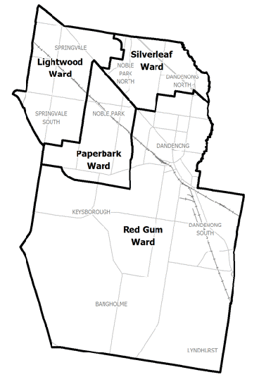
The municipality is located predominantly in the Dandenong catchment, in which Dandenong Creek is the major creek and tributaries include Bungalook Creek, Blind Creek, Eumemmerring Creek, Corhanwarrabul Creek and Mile Creek.
Significant major flooding occurred on the Dandenong Creek in 1984 and 2005 with many minor flood events occurring.
Dandenong Creek is the largest waterway and the main floodway through the Greater Dandenong Council region. It traverses approximately north-east to south-west from the Dandenong Ranges National Park and discharges into Mordialloc Creek and the manmade section of the Patterson River.
The urban characteristic of the area also means that rain water is not easily absorbed and tends to run off towards lower lying areas. During high intensity rainfall the amount of run off can lead to stormwater drains overflowing, causing flash flooding. Flash flooding occurs with little warning, only lasts a short time and can cause severe localised damage.
Noble Park Local Flood Guide
Click the button below to view the Local Flood Guide, which includes information about the local flood risk and how you can prepare for and respond effectively to floods.
Greater Dandenong Council Flood and Storm Emergency Plan
Municipalities can use Municipal Flood and Storm Emergency Plans to prepare, respond and recover from flood and storm events.
Click the button below to view the Municipal Flood and Strom Emergency Plan.
About Flood Guides
Communities can use local flood guides to identify and better understand their local flood risk. They include information about: flood history, how to prepare & respond to floods and who to contact.
Contact Information


Local SES Units
-
Greater Dandenong VICSES Unit:
42 Mills Road,
Dandenong, Victoria, 3175
Municipal Flood and Storm Plan
City of Greater Dandenong Storm and Emergency Plan - Updated April, 2019