Knox City Council

Flood information for the Knox City Council, encompassing local flood guides and a Municipal Flood Emergency Plan.

On this page:


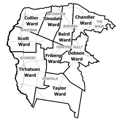
Knox city council municipal map.
Knox City Council municipal map.

Knox City Council has a history of flooding (riverine and flash flooding) including a significant flood
event in February 2011. Other significant floods have occurred in July 1995, July 1991, June 1989, July 1987 and September 1984. Locations at risk of flooding include Boronia, Bayswater, Wantirna, Wantirna South and Ferntree Gully.   

The lead time to respond to a flood event may be limited. All households and businesses at risk of flooding should develop an emergency plan and beware of their flood risk.

Households and business should refer to their Local Flood Guide or Knox City Council Flood Emergency Plan for more information.

Are you at risk of flood?

Knox flood guide map
Knox flood guide map - click to enlarge. 


Moderate to heavy rainfall over a period of 12 hours or more usually results in severe floodingwithin the City of Knox and this is caused by moist warm airflow from northern Australia. Riverine Flooding can occur after prolonged moderate to heavy rain, mostly occurring in summer and autumn.

Significant flooding can still occur during winter and spring. Flash flooding usually occurs in the summer with little warning. It generally affects small areas but damage can be severe. It occurs after high intensity rainfall, short in duration and is usually associated with thunderstorms.

The local urban drainage system rapidly reaches capacity during these events. The Blind Creek area is mainly residential with a light industrial area adjacent to Westfield Knox Shopping Centre. Areas at risk of flooding include:

  • The underground car park at Westfield Knox Shopping Centre

  • The intersection of Stud Road and Burwood Highway

  • High Street Road at the Blind Creek crossing

  • Wantirna Village (Retirement Village) on Old Stud Road in Wantirna South.

Are you at risk of flood?


Upper Ferntree Gully flood guide map
Upper Ferntree Gully flood guide map - click to enlarge.

Moderate to heavy rainfall over a period of 12 hours or more usually results in severe flooding within the City of Knox and this is caused by moist warm airflow from northern Australia.

Riverine Flooding can occur after prolonged moderate to heavy rain, mostly occurring in summer and autumn.

Significant flooding can still occur during winter and spring. Flash flooding usually occurs in the summer with little warning. It generally affects small areas but damage can be severe. It occurs after high intensity rainfall, short in duration and is usually associated with thunderstorms.

The local urban drainage system rapidly reaches capacity during these events. Areas at risk of flooding in Upper Ferntree Gully include:

  • Several educational facilities

  • The Ferntree Plaza Shopping Centre

  • Burwood Highway, Acacia Road, Clow Avenue, Dawson Street, Forest Oak Drive, Mount View Road, New Road, Rollings Road and Waters Avenue.

About Flood Guides

Communities can use local flood guides to identify and better understand their local flood risk. They include information about: flood history, how to prepare & respond to floods and who to contact.

Contact Information

For information on flood warnings, see the VicEmergency website.
Visit the Knox City Council website. 
Your local Catchment Management Authority: Melbourne Water.

Local VICSES Unit

Knox VICSES Unit:
  • 607 Burwood Hwy, Knoxfield

Municipal Flood Emergency Plan (MFEP)

Municipalities can use Municipal Flood Emergency Plans to prepare, respond and recover from flood and storm events.
Knox City Council  Emergency Storrm and Flood Plan