Moonee Valley City Council
Flood information for the Moonee Valley City Council, encompassing local flood guides and a Municipal Flood Emergency Plan.
Moonee Valley City Flood History
Mooney Valley City Council has a history of flooding (riverine flooding and flash flooding)including a significant flood event in September 1993.
Other significant flood events have occurred in 1871, 1891, 1906, 1916, 1924, 1954, 1974 and 1993.
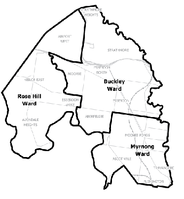
Locations at risk of flooding include:
-
Aberfeldie
-
Moonee Ponds
-
Ascot Vale
-
Airport West
-
Keilor West
-
Niddrie
-
Essendon West
-
Avondale Heights
-
Strathmore Heights
-
Strathmore
-
Essendon.
Tidal flows from Port Phillip Bay may also influence flooding in some locations within Mooney Valley City Council.
Aberfeldie Local Flood Guide
Are you at risk of flood?
This area is prone to flash flooding during heavy rainfall events that can result in road closures and effect private properties.
This guide provides an overview of the risk of flood and includes information that can help you to be more prepared in case of an emergency.
Aberfeldie is an established residential suburb on the southern boundaries of the City of Moonee Valley, located approximately nine kilometres north-west of the Melbourne Central Business District on the northern bank of the Maribyrnong River.
The map to the rigtht shows the impact of a 1% flood in the Aberfeldie area. A 1% flood means there is a 1% chance a flood this size could happen in any given year.
Ascot Vale Local Flood Guide
Are you at risk of flood?
Most areas of Melbourne experience some level of flooding during an extreme storm event, with those developed prior to the 1970’s generally being more likely.
The Maribyrnong River needs to be subject to major flooding levels before it would impact on properties within the Ascot Vale region. This is caused by significant rainfall occurring in the catchment area over an extended period of time.
Of greater risk are incidences of flash flooding where the Ascot Vale Main Drain can be overwhelmed through sudden, heavy rainfall and cause flooding in a number of streets close to the drain.
The map to the right provides an indication of flooding that could occur during an extreme 1% flood event, formerly referred to as a 1 in 100 year rainfall event. A 1% flood means there is a 1% chance a flood this size happening in any given year.
Moonee Valley Local Flood Guide
Are you at risk of flood?
The Moonee Valley area has a history of flooding due to its location on the Maribyrnong River and close proximity to other creeks.
The municipality can be affected by rising levels of the rivers and creeks (riverine flooding) or flash flooding caused by heavy rain over a short period of time.
Certain areas of Moonee Valley were established prior to 1914, when there were no regulations covering building in flood-prone areas. This means that in the older areas of Moonee Valley some buildings are located where it is likely to flood.
Along the Maribyrnong floodplain there are homes, properties and businesses at risk from floods. Historically, a large flood occurs every 10 to 20 years with 27 recorded floods in the area since 1871. So another large flood could occur at any time.
Suburbs at the greatest risk of flooding are those along the southern bank; Aberfeldie, Ascot Vale, Avondale Heights and Essendon West.
The map to the right provides an indication of flooding that could occur during an extreme 1% flood event, formerly referred to as a 1 in 100 year rainfall event. A 1% flood means there is a 1% chance a flood this size happening in any given year.
Streets in Moonee Valley at risk of flooding from the Maribyrnong River in a 1% flood event include:
-
The Boulevard, Aberfeldie
-
Angler Parade, Ascot Vale
-
Aspect Avenue, Ascot Vale
-
Gillespie Avenue, Ascot Vale
-
Harmony Road, Ascot Vale
-
Newsom Street, Ascot Vale
-
Stanford Street, Ascot Vale
-
Woods Street, Ascot Vale
Key community infrastructures at risk of flooding from the Maribyrnong River in a 1% flood event include:
-
Aberfeldie Park, The Boulevard, Aberfeldie
-
15th Essendon Sea Scouts, Woods Street, Ascot Vale
-
Riverside Golf and Tennis Centre, Newsom Street, Ascot Vale
-
Maribyrnong River trail in various locations
-
Riverside Park, The Boulevard, Aberfeldie Aberfeldie Park Athletics Track, Corio Street, Aberfeldie
-
Essendon Rowing Club and Boat Ramp, The Boulevard, Moonee Ponds
-
Walter Reserve, Walter Street Ascot vale
-
Fairbairn Park, Woods Street, Ascot Vale
-
Afton Reserve, The Boulevard, Essendon West.
About Flood Guides
Communities can use local flood guides to identify and better understand their local flood risk. They include information about: flood history, how to prepare & respond to floods and who to contact.
Contact Information
Local VICSES Unit
- Essendon Unit:
9 Rutherford St, - Aberfeldie, Victoria
- (currently operating out of 55 King Street, Airport West due to renovations)
Municipal Flood Emergency Plan (MFEP)
Moonee Valley Flood and Storm Emergency Plan - Updated Feb, 2018.