City of Ballarat

Flood information for the City of Ballarat, encompassing local flood guides and a Municipal Flood Emergency Plan.


On this page:


Ballarat Council municipal map.
  Ballarat municipal map.

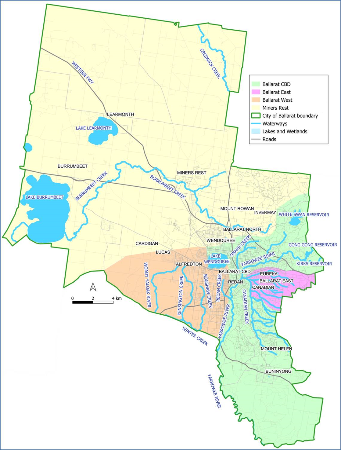
The City of Ballarat has a history of flooding which is mainly due to flash flooding after high intensity rainfall often associated with thunderstorms.

Other flooding is associated with flooding from rivers and creeks overflowing after prolonged rainfall.

  • In December 1991 severe thunderstorms brought intense rainfall, resulting in the largest flood events this century for both Ballarat East and Central Ballarat. In central Ballarat, Gnarr Creek caused flood and stormwater damage to homes and businesses, with the Lydiard Street area the worst affected

  • More recently, several areas of Ballarat, including Miners Rest, Ballarat East, Delacombe and Alfredton, experienced flooding in January 2011 after prolonged heavy rainfall fell across Victoria

  • The lead time to respond to a flood event may be limited. All households and businesses at risk of flooding should develop an emergency plan and beware of their flood risk.


Are you at risk of flooding?

Past floods impacting Ballarat CBD


Flooding in Ballarat CBD is usually caused by very heavy rainfall from local thunderstorms. These flash floods rise and fall quickly, so you may not receive any warning.

Flash floods can result in swift water running down streets and footpaths posing a serious risk to pedestrians, partcularly children. Flooding from Gnarr Creek is the major flood risk to the Ballarat CBD. During heavy rain Gnarr Creek can overflow its channel near Doveton St and flow down Market, Mair and Grenville Streets before flooding the Bridge Mall. Gnarr Creek rises very quickly during major storms and can take as little as two hours to reach peak flood heights.

The Yarrowee flood threat has been substantially reduced by the construction of the Western Freeway Bypass as it provides protection by retarding flash flood surges down the Yarrowee River. Flood retarding basins have been constructed in the upper catchment of Gnarr Creek.

These significant drainage and flood mitigation works undertaken since 1991 have improved drainage, however there is still a high risk of major flash flooding in the CBD. The map below shows areas that would be flooded if a large flood similar to the December 1991 flood happened today.

Are you at risk of flood?

Ballarat East flood map
  Click to enlarge. 

Low-lying areas near the creeks are at risk of flash flooding after heavy storms or during long rainfall events.

Flash flooding occurs when Canadian Creek and its streams become full and overflow into nearby land.

Floods in Ballarat East, Canadian, Golden Point and Eureka rise and fall, and move quickly (normally within hours) so you may not receive a warning.

Because of the quick nature of flooding in these areas, roads can be closed with little notice and flooded roads are very dangerous for people who are walking.

The map to the right shows the areas that may be concerned by floodwater in a flood that has a 1% chance of happening in any given year.

Are you at risk of flooding?

Expected flooding in Miners Rest gauge
Expected flooding in Miners Rest

Miners Rest can be affected by stormwater flooding and/or flash flooding. Stormwater flooding occurs when heavy rainfall causes stormwater drains to overflow and flash flooding occurs when heavy rain causes Burrumbeet Creek to spill over its banks.

During stormwater flooding, water overflows into low-lying areas and floods roads and adjoining properties. During major storms, flooding of properties usually occurs 3-6 hours after the start of heavy rainfall with water levels peaking at 7–10 hours. Areas prone to stormwater flooding include low-lying areas of James Court, Douglas Close, Dundas Place and Clarke Street near Douglas Close. Flash flooding from Burrumbeet Creek occurs when intense rainfall causes Burrumbeet Creek to overflow and flood into surrounding areas.

Areas prone to flooding from Burrumbeet Creek occurs when heavy rainfall causes stormwater drains to overflow and flash flooding occurs when heavy rain causes Burrumbeet Creek to spill over its banks. During stormwater flooding, water overflows into low-lying areas and floods roads and adjoining properties. During major storms, flooding of properties usually occurs 3-6 hours after the start of heavy rainfall with water levels peaking at 7–10 hours.

Areas prone to stormwater flooding include low-lying areas of James Court, Douglas Close, Dundas Place and Clarke Street near Douglas Close. Flash flooding from Burrumbeet Creek occurs when intense rainfall causes Burrumbeet Creek to overflow and flood into surrounding areas.

Areas prone to flooding from Burrumbeet Creek include:

  • Creek Street

  • Hamlin Street

  • Top end of Victoria Street

  • Albert Street between Victoria Street/Dundas Place

  • Cummins Road

  • Parts of Sharpes Road and Raglan Street.

These two types of flooding can happen separately or at the same time, depending on where rain falls and its intensity.

About Flood Guides

Communities can use local flood guides to identify and better understand their local flood risk. They include information about: flood history, how to prepare & respond to floods and who to contact.

Contact Information

For more information, contact the Mid West Region Headquarters.
For information on flood warnings, see the VicEmergency website
Your local Catchment Mangement Authority: Corangamite.

Local VICSES Unit

Ballarat VICSES Unit:
115A Gillies Street,
Ballarat, 3350

Municipal Flood Emergency Plan (MFEP)

Municipalities can use Municipal Flood Emergency Plans to prepare, respond and recover from flood and storm events.
City of Ballarat Flood Emergency Plan - Updated Nov, 2019.