City of Greater Geelong

Flood information for the City of Greater Geelong, encompassing local flood guides and a Municipal Flood Emergency Plan.

On this page:


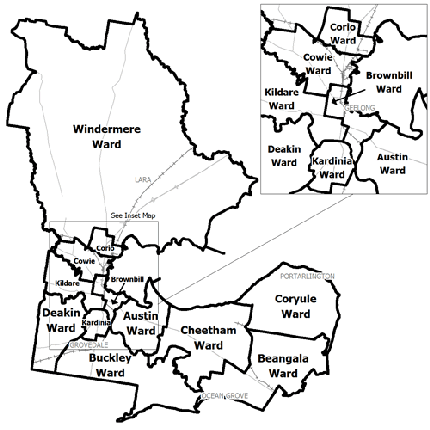
city of geelong municipal map
Greater Geelong municipal map.

Geelong is situated at the meeting point of the Moorabool and Barwon Rivers and sits on Corio Bay. In Geelong, there are a number of areas lining the Barwon River subject to flooding.

Along the Barwon river there are many homes and businesses at risk of flooding. Geelong has a history of significant flooding from the river including in 1909, 1952, 1978, 1983, 1995 and 2001.

Areas that sit on the Barwon River such as parts of Fyansford, Highton, Newtown, Belmont, Breakwater and South Geelong are at risk of flooding from the river.

Since 1852 there have been approximately 14 large floods in the region, with large flooding occurring on average every 10-12 years.

Flash flooding can occur with little to no warning in many parts of Geelong, including the CBD and surrounds.

Households and business should refer to their Local Flood Guide or Municipal Flood Emergency Plan  for more information.

Are you at risk of flood?

Along the Barwon River there are manyGeelong flood levels gauge McIntyre Bridge homes and businesses at risk of flooding. Geelong has a history of significant flooding from the river including in 1909, 1952, 1978, 1983, 1995 and 2001.

Areas that sit on the Barwon River such as parts of Fyansford, Highton, Newtown, Belmont, Breakwater and South Geelong are at risk of flooding from the river. Since 1852 there have been approximately 14 large floods in the region, with large flooding occurring on average every 10-12 years.

Flash flooding can occur with little to no warning in many parts of Geelong, including the CBD and surrounds. 

The table to the right gives an indication of how Geelong will be impacted at different levels based on river height levels recorded on the McIntyre Bridge Gauge.

Are you at risk of flood?


impact of flooding in the area at 6.0 metres on the McIntyre Bridge Gauge in Geelong
  Click to enlarge.

Barwon Heads and Ocean Grove are subject to flooding from the Barwon River. In addition, stormwater runoff in Barwon Heads is released into the Barwon River through storm water pipes and pumps or into groundwater in the region, increasing the risk of stormwater and flash flooding.

Barwon Heads and Ocean Grove can also experience flash flooding from heavy rainfall overwhelming the local drainage system. The effects of storms and flooding is likely to impact areas close to Murtnaghurt Lagoon, west of the Barwon Heads township.

Areas of Barwon Heads and Ocean Grove are also subject to flooding from tidal surge. Floods can be more severe when combined with a king tide. 

Barwon Heads and Ocean Grove have a history of flooding including in 1880, 1909, 1951, 1952, 1973, 1978, 1995 and 2002. In 2002, flash flooding occurred when 89 millimetres of rain fell in the area over 24 hours.

Local knowledge indicates that the most severe flood experienced in the area was in 1952 which measured 1.9 metres on the Sheepwash Road Gauge. This flood was caused when 560 millimetres of rain fell over four days in the Otways Catchment, flowing down the Barwon River.

The map to the right shows the impact of flooding in the area at 6.0 metres on the McIntyre Bridge Gauge in Geelong, which is used for Flood Warnings for the area.

Are you at risk of flood?

Lara flood map
Lara flood information map.

Hovells Creek is a shallow, slow moving watercourse that is filled when rain falls in the Northwestof the catchment and flows down through the Creek.

In heavy rainfall or in sustained rainfall over a number of days, homes and businesses in and around the township of Lara can flood and the town may be divided by the Hovells Creek floodplain.

In particular, the town centre is at risk of flooding, as the drainage networks become full and water builds up, spilling over into surrounding areas.

Due to the particularly flat nature of the landscape in the North East of Lara, flooding in the town lasts for a number of days. As there is a risk of flooding in the area, the City of Greater Geelong developed a flood warning system for Hovells Creek following the 1988 flood.

The warning system consists of three gauges in the Hovells Creek catchment area that transmits rainfall details to a base station and is then analysed to determine if there is a threat to residents. This network was built and is maintained by the Council and allows residents to receive a warning through usual channels for potential flooding.

Following the 1973 flood, a levee was constructed and completed in 1986. Following the 1988 flood the levee had to be repaired and approximately 600 millimetres was added to the height of the levee in some areas.

Are you at risk of flood?

Batesford Local Flood Guide map
Batesford flood map - click to enlarge
  • Flooding around the Moorabool River at Batesford can occur after consecutive days of moderate to heavy rainfall in the area causing the river level to rise.

  • Significant riverine floods have been recorded in 1911, 1916, 1952, 1978 and 1995, along with smaller recent floods in January 2011 and September 2016.

  • In minor to moderate flood events, the flood water is generally contained to the floodplain area adjacent to the waterway, also impacting on some crown and agricultural land. However, in a moderate to major flood, floodwater can impact several houses around River Street, Bridge Street, Cross Street, and the Midland Highway.

The map (right) shows the expected riverine flooding in Batesford when the Moorabool River measures 4.75m at the Batesford gauge. This height is 0.15m below the ‘major’ flood level (refer to page 4 of the Local Flood Guide). 

About Flood Guides

Communities can use local flood guides to identify and better understand their local flood risk. They include information about: flood history, how to prepare & respond to floods and who to contact.

Contact Information

For more information, contact the South West Headquarters.
For information on flood warnings, see the VicEmergency website
Your local Catchment Mangement Authority: Corangamite 

Local VICSES Units

Geelong VICSES Unit:
4 Wood Street,
South Geelong

  • Corio VICSES Unit:
    299 Anakie Road,
    Lovely Banks

  • South Barwon VICSES Unit:
    13-39 Rossack Drive,
    Grovedale

  • Bellarine VICSES Unit:
    702 Grubb Road,
    Drysdale

Municipal Flood Emergency Plan (MFEP)

Municipalities can use Municipal Flood Emergency Plans to prepare, respond and recover from flood and storm events. City of Greater Geelong MFEP, Updated August 2022.