Mount Alexander Shire Council

Flood information for the Mount Alexander Shire Council, encompassing local and Flood Emergency Plan.

On this page:

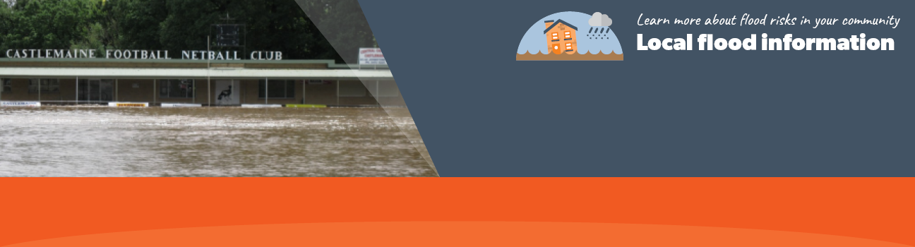
Mount Alexander Shire Council has a history of flooding including a significant flood event in January 2011 which is the highest flood in the municipality on record. The flood/ storm event had a severe impact on all communities in the municipality.  

Mount Alexander is typically threatened by flash flooding- short duration, high intensity rainfall, this occurs more frequently between October and March. These rainfall events can cause disturbances to drainage infrastructure and capacity to be reached quickly with very little warning.

The lead time to respond to a flood event may be limited. All households and businesses at risk of flooding should develop an emergency plan and be aware of their flood risk.

Households and businesses should refer to their Local Flood Guide or Mount Alexander Flood Emergency Plan for more information.


Are you at risk of flood?

Baringhup flood map
 Click to enlarge.


The length of time between the inflows into Cairn Curran and the reservoir spilling is dependent on the storage levels of the reservoir before the rain occurs, and the severity and duration of the rainfall into the catchment upstream of the reservoir.

When the reservoir does spill, steep rises in floodwater can occur in Baringhup within 30 minutes of spilling and flooding can last for up to four days.

High inflows into Cairn Curran when storage levels are high, as was the case in the January 2011 flood event, will:

  • Increase the likelihood of flooding occurring at Baringhup.

  • Reduce the travel time of the flood peak.

In early September 2016 when steep rises were recorded in other parts of the Loddon catchment, Cairn Curran’s storage capacity was 37% and flooding did not occur in Baringhup.

The map to the right shows the approximate extent of flooding during the January 2011 flood event.

Are you at risk of flood?

Castlemaine, Campbells Creek, Chewton flood map
Click to enlarge.

Chewton lies alongside Forest Creek which meets Barkers Creek at Castlemaine. These form
Campbells Creek which then passes through the township of Campbells Creek on its way to the Loddon River at Guildford.

Castlemaine, Campbells Creek and Chewton have a history of flash flooding from heavy rain falling over a short period of time.

Historically, flash flooding has occurred so quickly that there has been no time for a warning. It is important for residents to be aware of the potential for future flash flooding and plan for it.

The map to the right shows the potential extent of flooding in a 1% Annual Exceedance Probability (AEP) event. A 1% AEP flood means there is a 1% chance of a flood of this size occurring in any year.


Are you at risk of flood?

Newstead flood map
  Click to enlarge.

The Loddon River rises in the mountains between Daylesford and Kyneton and flows northwest passing through the townships of Guildford and Newstead before entering Cairn Curran Reservoir.

A number of creek systems join the Loddon River upstream of Newstead. These include Campbells Creek, Jim Crow Creek, Green Gully Creek, Mia Mia Creek and Muckleford Creek. Heavy rainfall in these waterways can lead to flooding in Newstead.

Newstead has a long history of flooding and as a result, a levee bank was built on the east side of the river in the 1920’s. While the formal protection level of the levee is unknown, the levee has protected the town during recent flood events in September 2010, September 2016 and January 2011.

However a number of properties are outside the levee and were inundated during the floods of 2010-2011. A Flood Watch or Flood Warning for Newstead is predicted from a series of gauges located in the Loddon River catchment: Vaughan, Newstead, Yandoit on the Jim Crow Creek, and Muckleford on the Muckleford Creek. How long it takes to flood from the time it starts raining will depend on how wet the rivers, creeks and soil already are, the amount of rainfall and how quickly it falls.

The following maps show the potential extent of flooding in a 1% Annual Exceedance Probability (AEP) event. A 1% AEP flood means there is a 1% chance of a flood of this size occurring in any year.

About Flood Guides

Communities can use local flood guides to identify and better understand their local flood risk. They include information about: flood history, how to prepare & respond to floods and who to contact.

Contact Information

For more information, contact the  North West Regional Headquarters.
For information on flood warnings, see the VicEmergency website.
Your local Catchment Mangement Authority: North Central.

Local VICSES Unit

  • Castlemaine VICSES Unit:
    1 Scott's Avenue
    Castlemaine, VIC,
    3450.

Municipal Flood Emergency Plan (MFEP)

Municipalities can use Municipal Flood Emergency Plans to prepare, respond and recover from flood and storm events. Mount Alexander Shire  Emergency Management Plan - Updated July, 2019.