


Flood information for the Glen Eira City Council, encompassing the local flood guide and a Municipal Flood Emergency Plan.
Glen Eira Flood History
Glen Eira City Council has a history of flooding including a significant flood event in January 2011 and is the highest flood in the municipality on record in over a decade. More than 150 homes and business were damages and around 200 properties affected.
Glen Eira City Council is typically threatened by flash flooding- short duration, high intensity rainfall, this occurs more frequently between October and March. These rainfall events can cause disturbances to drainage infrastructure and capacity to be reached in the Elwood Cannal in as quickly as 3-6 hours. Less significant flooding can also occur in winter after prolonged periods of rainfall.
The lead time to respond to a flood event may be limited. All households and businesses at risk of flooding should develop an emergency plan and beware of their flood risk.
Households and business should refer to their local warnings or Glen Eira Flood Emergency Plan for more information.
The City of Glen Eira has been impacted by heavy rainfall resulting in flash flooding on several occasions, including 1996, 2003, 2004, 2005, 2006, 2010, 2011, 2013, 2015, 2016, 2017. In February 2011, exceptionally high rainfalls, between 100-200 millimetres, resulted in flooding of numerous streets, properties and houses, some ending up with extensive damage. More than 150 homes and businesses were damaged and around 200 properties affected. A number of houses were rendered uninhabitable.
From flood modelling completed in Glen Eira in 2015, 8,800 properties are at risk of flooding during a 1% flood event and 1,288 properties are potentially at risk of over-floor flooding. A 1% event means there is a 1% chance of a flood this size happening in any given year.
Glen Eira Local Flood Guide
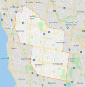
This guide is relevant for residents of
|
Click the button below to view the Local Flood Guide, which includes information about the local flood risk and how you can prepare for and respond effectively to floods.
Glen Eira City Council Flood and Storm Emergency Plan
Municipalities can use Municipal Flood and Storm Emergency Plans to prepare, respond and recover from flood and storm events.
Click the button below to view the Municipal Flood and Strom Emergency Plan.
About Flood Guides
Communities can use local flood guides to identify and better understand their local flood risk. They include information about: flood history, how to prepare & respond to floods and who to contact.
Contact Information


Local SES Units
- Glen Eira VICSES Unit
92 Bignell Rd
Bentleigh East
VIC 3165