Golden Plains Shire Council

Flood information for the Golden Plains Shire Council, encompassing local flood guides and a Municipal Flood Emergency Plan.

On this page:


Golden Plans Municipal map
Golden Plains municipal map

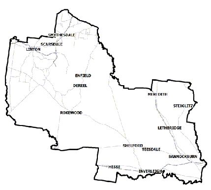
Golden Plains Shire Council has a number of rivers, creeks and waterways at risk of flooding. The town of Inverleigh is located where the Leigh River and the Barwon River meet, meaning that the town can experience extensive flooding if the two rivers flood at the same time. Shelford is impacted by flooding of the Leigh River.

As well as impacting Shelford and Inverleigh, in 2010 and 2011 localised flooding occurred in the north-western regions of the shire around Haddon, Smythesdale and Smythes Creek.

Flood warning systems are in place for Inverleigh and Shelford through the Bureau of Meteorology. The lead time to respond to a flood event may be limited.  Households and businesses should refer to their Local Flood Guide or Municipal Flood Emergency Plan for more information.

Are you at risk of flood?

Golden plains flood guide map
  Click to enlarge.

As far back as the 1870’s floods were a problem for Shelford, and in 1880 an embankment was constructed along the Leigh River to reduce flooding in Shelford.

The last two major Leigh River floods, in February 1973 and January 2011, flooded the Leigh floodplain on the eastern outskirts of Shelford resulting in the inundation of 8 houses, the school, the recreation reserve, and the Presbyterian Church.

Two historic levees are located on the Leigh floodplain. The northern levee was constructed to protect Shelford properties to the east of the Leigh River.

During major floods local observation indicates that floodwater quickly moves around this levee, leading to the flooding of properties on the east side of the river.

While no two floods are the same, floods like 2011 or worse will occur again. Even if your property is not affected by floodwater, you may be affected indirectly as roads may be closed and power and sewerage services may be disrupted. 

The map to the right shows the extent of the January 2011 flooding in Shelford. This flood measured 7.90 metres on the Leigh River Gauge at Shelford and 4.21 metres on the Leigh River Gauge at Mount Mercer, located 25 kilometres north of Shelford. This flood represents one possible scenario for flooding in the Shelford area.

Are you at risk of flood?

Inverleigh Flood Gauge
Inverleigh Flood Gauge (extract from Local Flood Guide)

Flooding in Inverleigh can occur by riverine flooding from the Leigh River and/or the Barwon River. The majority of the township is affected by flooding from the Leigh River however if the peak water height in the Leigh and Barwon Rivers reach Inverleigh at the same time then Inverleigh township is likely to flood.

The Leigh River usually floods Inverleigh after long heavy rainfall in the area around Mt Mercer and Ballarat.

Areas of Inverleigh that may be impacted when the Leigh River floods include Teesdale-Inverleigh Road, River Reserve (between town and junction of the rivers,) Federation Bridge, Dawber Road, Burkes Road, northern football ground, levee beside tennis courts, Inverleigh Primary School, Hamilton Highway (west of town,) Cambridge Street, High Street, Newman Street, East Street and Terrier Road.

Flooding of Inverleigh from the Barwon River is usually a result of long heavy rainfall in the Otway Ranges. When the Barwon River floods, rural residential properties on the southern side of Inverleigh are at risk of flooding.

Areas of Inverleigh township that may also be impacted when Barwon River floods include Park and River Reserve, River Road, Inverleigh-Winchelsea Road, Costains Road, Rawson Road, East Street and McCallum Road.

Localised heavy rainfall around the township itself is likely to cause flash flooding but will generally cause only a minor water height rise in Leigh River and Barwon River levels.

Are you at risk of flood?

Batesford Local Flood Guide map
Batesford flood map - click to enlarge
  • Flooding around the Moorabool River at Batesford can occur after consecutive days of moderate to heavy rainfall in the area causing the river level to rise.

  • Significant riverine floods have been recorded in 1911, 1916, 1952, 1978 and 1995, along with smaller recent floods in January 2011 and September 2016.

  • In minor to moderate flood events, the flood water is generally contained to the floodplain area adjacent to the waterway, also impacting on some crown and agricultural land. However, in a moderate to major flood, floodwater can impact several houses around River Street, Bridge Street, Cross Street, and the Midland Highway.

The map (right) shows the expected riverine flooding in Batesford when the Moorabool River measures 4.75m at the Batesford gauge. This height is 0.15m below the ‘major’ flood level (refer to page 4 of the Local Flood Guide). 

About Flood Guides

Communities can use local flood guides to identify and better understand their local flood risk. They include information about: flood history, how to prepare & respond to floods and who to contact.

Contact Information

For more information, contact the Mid West Region Headquarters.
For information on flood warnings, see the VicEmergency website.
Visit the Golden Plains Shire Council website.
Your local Catchment Mangement Authority: Corangamite

Local VICSES Unit

Bannockburn VICSES Unit:
25 High Street,
Bannockburn.

Municipal Flood Emergency Plan (MFEP)

Municipalities can use Municipal Flood Emergency Plans to prepare, respond and recover from flood and storm events.
Golden Plains Shire Council Flood Emergency Plan - Updated Feb, 2020