Shepparton City Council

Flood information for the Greater Shepparton City Council, encompassing local flood guides and a Municipal Flood Emergency Plan.

On this page:


Maroopna Flood map
Greater Shepparton City Council municipal flood map.

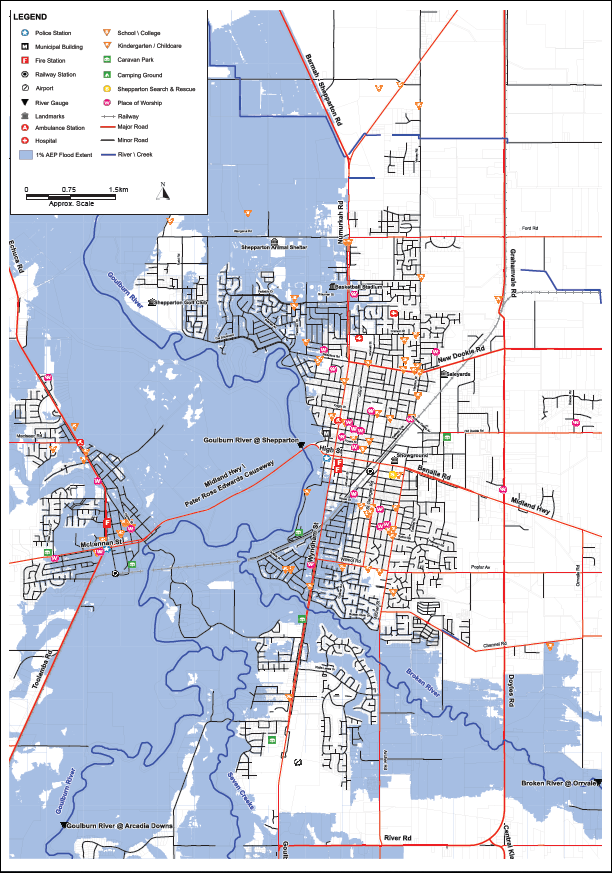
The Greater Shepparton City Council has a history of flooding including in 1870, 1916, 1974, 1993 and more recently in 2010:

  • 1974 was a Goulburn River dominant flood

  • 1993 was a Broken River dominant flood

  • 2010 was a flood which saw gauges on the Goulburn, Broken and Seven Creeks peak at major level.

    During this flood, 13 houses and 31 buildings were flooded, 620 houses were isolated and more than 60 people attended the relief and recovery centre.

Floods like this or worse could occur again. Even if your property is not affected by floodwater, you may be impacted indirectly by road closures, isolation and disruption to essential services including telephones, power and sewerage. Flooding from the rivers in this area usually lasts about four to seven days depending on the rainfall. Roads and properties can also flood due to water backing up in the stormwater drain system.

Flash flooding caused by heavy rainfall can also occur in low-lying areas, especially in the industrial and business areas of Mooroopna and Shepparton East and around the Doyle’s Road- Midland Highway roundabout. These flash floods only last a few hours but can be dangerous and cause extensive damage.

Are you at risk of flood?

Congupna rainfall gauge

Flash flooding in the Congupna area can occur when heavy rain falls over a short period of time.

Flash flooding is likely to result in approximately six homes becoming inundated and the town’s drainage network being overwhelmed causing access roads to flood for several - for example, Katamatite-Shepparton Main Road.

Congupna can also be at risk of riverine flooding when significant rain falls on the Broken River catchment area (eg 1993). Congupna’s main flood risk comes from Pine Lodge and O’Keefe Creeks that flow toward Congupna particularly when the Broken River floodwater merges with these local creeks.

When the Broken River floods it can spill over its banks in many places, often along the river section between the Gowangardie Weir and the East Goulburn Main Channel where it spreads north easterly towards Congupna and Pine Lodge Creek etc.

During big floods, several homes adjacent to Pine Lodge Creek may experience some inundation. It usually takes 24 - 48 hours for riverine floods to peak in the Congupna area after the Broken River floods and may last one or more weeks or even months.

Large pockets of water can remain in low-lying farming areas which impacts how long water will take to drain away.

The table to the right gives an indication of rainfall levels that are likely to cause flooding in the area. The impact of rainfall can vary for a number of reasons including how wet the ground is prior to the rainfall and how quickly it falls.

Are you at risk of flood?

Katandra West Flood gauge table
  Click to enlarge.

The Katandra West district has experienced flooding in previous years including 1919, 1939,1956, 1974, 1993 and most recently in 2012.

During significant flooding the nearby Congupna and Guilfus Creeks will begin to fill and may overflow, flooding the surrounding area and threatening farming properties to the west of the town.

These same creeks can also flood if local heavy rain falls on the Dookie Hills such as in 2012. This flood caused the town’s drainage network to be overwhelmed by the volume of water making its way across town causing Black Street, Coleman Street, Burgman Street, Hickey Road, Donohue Street and King Street to flood for several days.

Flooding in the Labuan Road area lasted longer than in the town. Generally, rainfall of 75 millimetres or more in a 24 hour period will result in similar or worse flooding. Floods in the past have not resulted in homes in the town being flooded above floor level.

Are you at risk of flood?

Maroopna Flood map
  Click to enlarge.

Shepparton, Mooroopna & Kialla have Riverine Flood risks because there are many nearby waterways.

Flash flooding is also a risk in Greater Shepparton because the land is so flat. After heavy rain, flash floods can rise very quickly, leaving water sitting over roads and paths for hours before draining away.

The Goulburn River, or Gaiyila in Yorta Yorta language, lies between Shepparton and Mooroopna and flows
from Lake Eildon, Seymour, and Nagambie. Before the Goulburn River reaches Shepparton, 3 important
waterways flow into it:

  • Closest to town, the Broken River comes from Benalla to meet the Goulburn River near Shepparton Botanic Gardens. It is the border between Shepparton and Kialla.

  • Not far from there, the Seven Creeks meets the Goulburn River at the bottom of Riverview Drive, Kialla, after flowing from Euroa and the Strathbogie Ranges.

  • Further out, the Castle Creek also flows into the Goulburn at Arcadia.

When multiple waterways meet like this (called a confluence) flooding will be different depending on which river or creek floods the most, how high each stream reaches, and which peaks first. Releases from Lake Eildon can also affect Goulburn River flows.

Are you at risk of flood?

Murchinson flood map
  Click to enlarge.

Most of the Murchison township is believed to be safe from flooding except during very large floods. However, low-lying properties, farmland, fishing spots and camping areas can often be affected by minor to moderate flooding.

River levels can rise within several hours of heavy rain, and during floods, floodwater can travel from Goulburn Weir to Murchison in 12-15 hours and from Seymour to Murchison in three to three and a half days. Be aware that floods can affect your property before the peak arrives and no two floods are the same.

During a major flood, the main bridge and rail trail as well as roads to Shepparton, Violet Town and Bendigo may be closed or damaged. Several homes in the Willoughby Street area and low-lying properties along Phillip Lane, High, Hutchison and Gillam Roads may be flooded or isolated. In addition, the River Haven Caravan Park, Murchison Caravan Park and farms close to the river may be flooded or isolated.

Community facilities that may also be at risk of flooding include the Murchison swimming pool, low-lying areas of the cemetery, and the camping and fishing spots north of the Bridge.


Are you at risk of flood?

Tallygroopna Flood gauge table

The main source of flooding in Tallygaroopna comes from a number of creeks that flow toward and around Tallygaroopna, including:

  • Congupna Creek
  • Guilfus Creek
  • Pine Lodge Creek
  • Dainton’s Creek
  • O’Keefe Creek

When the Broken River floods it can spill over or break its banks in many places, often along the river section between one kilometre east of Gowangardie Weir through to Pine Lodge at the East Goulburn Main Channel.

From this break-out, floodwater spreads north westerly towards Tallygaroopna where it merges with these local creeks and causes flooding in the town. This type of flooding can last for one or more weeks, or even months, as water can remain in low-lying farming areas.

Victoria Road, Goulburn Valley Highway (North and South bound), Bowey Road and Tallygaroopna West / Bunbartha Road are all subject to flooding after significant rainfall.

The table to the right gives an indication of what rainfall levels are likely to cause flooding in the area. The impact of rainfall can vary due to a number of factors including how wet the ground is prior to the rainfall and how quickly it falls.

About Flood Guides

Communities can use local flood guides to identify and better understand their local flood risk. They include information about: flood history, how to prepare & respond to floods and who to contact.

Contact Information

For more information, contact the Hume (North East) Regional Headquarters.
For information on flood warnings, see the VicEmergency website.
Visit the Shepparton City Counicl website.
Your local Catchment Mangement Authority: Goulburn Broken.

Local SES Units

Tatura VICSES Unit:
Martin St & Russell St,
Tatura.

Municipal Flood Emergency Plan (MFEP)

Municipalities can use Municipal Flood Emergency Plans to prepare, respond and recover from flood and storm events.
Shepparton City Council Flood and  Emergency Plan - Updated July, 2023.