


Flood information for the Hindmarsh Shire Council, encompassing local flood guides and a Municipal Flood Emergency Plan.
Hindmarsh Flood History
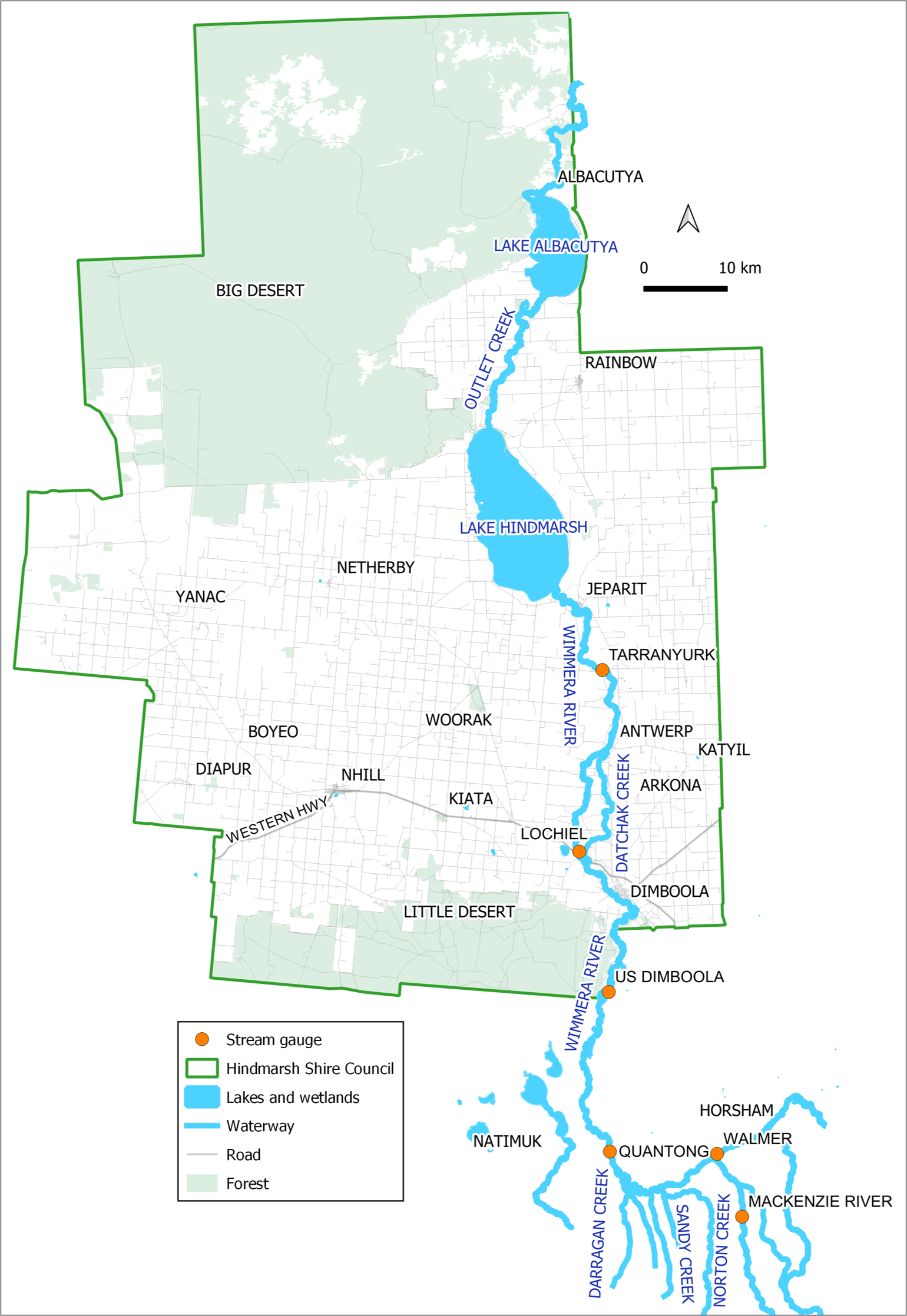
Hindmarsh Shire Council has towns that are subject to stormwater and riverine flooding. Towns that are impacted by stormwater flooding include Jeparit, Dimboola, Rainbow and Nhill.
Hindmarsh Shire has a long history of riverine flood events. Towns impacted by riverine flooding include Jeparit and Dimboola.
While flood events within the Hindmarsh Shire have been frequent over the last decade, the frequency of flood events has reduced since 1996.
Prior to 1996 flood events in the Wimmera River occurred on average once every four years. Water diversion to storages in the upper catchment of the GWMWater stock and domestic water supply system has significantly reduced flooding in Dimboola, Jeparit and the downstream terminal lakes.
Given these storages have the capacity (770,000 ML) to capture a significant proportion of high flows over a long period, water diversion to these storages has significantly reduced the frequency and magnitude of flooding in Dimboola, Jeparit and downstream terminal lakes, Lake Hindmarsh and Lake Albacutya.
The most significant recent flood event was recorded in 2011.
The major waterways within the Hindmarsh Shire Council are:
- Wimmera River
- MacKenzie River
- Norton Creek, Sandy Creek, Darragan Creek
- Datchak Creek
Further information on the flood history of the area can be found in the Hindmarsh Shire Council Flood Emergency Plan.
Dimboola Local Flood Guide
Jeparit Local Flood Guide
Hindmarsh Shire Council Flood and Storm Emergency Plan
Municipalities can use Municipal Flood and Storm Emergency Plans to prepare, respond and recover from flood and storm events.
Click the button below to view the Municipal Flood and Strom Emergency Plan.
About Flood Guides
Communities can use local flood guides to identify and better understand their local flood risk. They include information about: flood history, how to prepare & respond to floods and who to contact.
Contact Information


Local SES Units
- Nhill VICSES Unit:
92B Nelson St,
Nhill, Vicotira
Dimboola VICSES Unit:
6 Lochiel St,
Dimboola, Victoria
Municipal Flood and Storm Plan
Municipalities can use Municipal Flood and Storm Plans to prepare, respond and recover from flood and storm events. Hindmarsh Shire Council Flood Emergency Plan - Updated April, 2020