


Flood information for the Hume City Council, encompassing local flood guide and a Municipal Flood Emergency Plan.
Hume Flood History
Hume City Council has a history of flooding including significant flood events in 1977 and 1978, which impacted the township of Keilor and surrounding areas. Other locations at risk of flooding include Sunbury, Campellfield, Craigieburn, Coolaroo and Broadmeadows.
The lead time to respond to a flood event may be limited. All households and businesses at risk of flooding should develop an emergency plan and beware of their flood risk.
Households and business should refer to their Local Flood Guide or Hume City Council Flood Emergency Plan for more information.
Hume Local Flood Guide
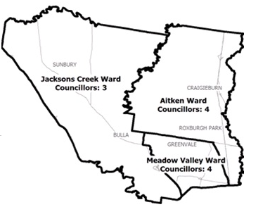
This guide is relevant for residents of
|
|
|
Click the button below to view the Local Flood Guide, which includes information about the local flood risk and how you can prepare for and respond effectively to floods.
Hume City Council Flood and Storm Emergency Plan
Municipalities can use Municipal Flood and Storm Emergency Plans to prepare, respond and recover from flood and storm events.
Click the button below to view the Municipal Flood and Strom Emergency Plan.
About Flood Guides
Communities can use local flood guides to identify and better understand their local flood risk. They include information about: flood history, how to prepare & respond to floods and who to contact.
Contact Information


Local SES Units
-
Fawkner VICSES Unit:
1161 Sydney Rd,
Hadfield, Victoria 3046
Craigieburn VICSES Unit:
151a Craigieburn Road,
Craigieburn Victoria 3064 -
Sunbury VICSES Unit:
17 McDougall Road,
Sunbury Victoria 3429
Municipal Flood and Storm Plan
Municipalities can use Municipal Flood and Storm Plans to prepare, respond and recover from flood and storm events.
Hume City Council Flood and Storm Emergency Plan - Updated May, 2020
This municipal flood and storm management plan is currently being updated. The revised and updated plan will be available soon.