


Flood information for the Macedon Ranges Shire Council, encompassing local flood guides and a Municipal Flood Emergency Plan.
Macedon Ranges Flood History
Macedon Ranges Shire experiences both riverine flooding and flash flooding. There are a large number of creeks within the Shire that are subject to flooding as well as the Campaspe and Coliban Rivers.
Flooding affects rural areas along the creeks, many local and larger roads and a number of the urban areas.
Prolonged moderate to heavy rain often leads to riverine flooding within the municipality. Generally, a wet catchment and a period of heavy rain are required to produce severe flooding.
Are you at risk of flood?
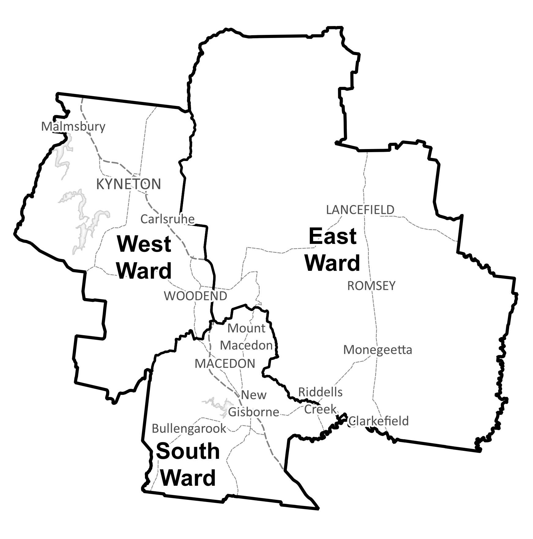
Key waterways in the Shire include the Campaspe and Coliban Rivers, as well as Deep, Riddells, Bolinda, Jacksons and Five Mile creeks. Many of the Shire’s natural waterways originate in the ranges (higher areas) and flow southeast to the flat, lower parts.
Most of these are tributaries of the Maribyrnong River, which forms to the southeast of the municipality. The main flooding risks are associated with tributaries to the Maribyrnong River, particularly Deep Creek and Jacksons Creek. Deep Creek rises to the east of Woodend on the northern face of the ranges and flows through Lancefield and Romsey before joining with Boyd Creek at Darraweit Guim. It passes out of the municipality to the southeast and joins the Maribyrnong River a few kilometres upstream of Bulla. Jacksons Creek flows from above Rosslynne Reservoir, passes through Gisborne and joins the Maribyrnong River a few kilometres downstream from Bulla.
The Campaspe River and in many tributary creeks including the Coliban River, drain the western and northern parts of the Shire. The Coliban River originates just outside the Shire but passes through its north-western edge. These two large rivers can present flooding issues in Kyneton and Malmsbury, towns in the west of the municipality.
Five Mile Creek, one of the Campaspe tributaries causes flooding problems in Woodend. A small area of the Shire to the south of Gisborne is within the Werribee River basin and drains to the Werribee River. There are a number of reservoirs within the municipality, notably Rosslynne Reservoir, just upstream of Gisborne, and Upper Coliban, Lauriston and Malmsbury Reservoirs on the Coliban River near Malmsbury.
Several smaller reservoirs exist in the headwaters of Riddells Creek, on the southern slopes of Mount Macedon. The status of these storages in the lead up to and during a storm event can have a large impact on downstream flood levels and inundation extents.
Macedon Ranges Shire Council Local Flood Guide
At this time, there are no Local Flood Guides for the Macedon Ranges Shire Council area. Go to the Plan and stay safe page for information on how you can plan and prepare for emergencies.
Macedon Ranges Shire Council Flood and Storm Emergency Plan
Municipalities can use Municipal Flood and Storm Emergency Plans to prepare, respond and recover from flood and storm events.
Click the button below to view the Municipal Flood and Strom Emergency Plan.
About Flood Guides
Communities can use local flood guides to identify and better understand their local flood risk. They include information about: flood history, how to prepare & respond to floods and who to contact.
Contact Information


Local SES Units
-
Gisborne VICSES Unit:
33 Robertson Street,
Gisborne 3437 -
Woodend VICSES Unit:
26 Urquhart Street,
Woodend 3442
Municipal Flood and Storm Plan
Macedon Ranges Shire Flood Emergency Plan - Updated June, 2023