


Flood information for the Manningham Council, encompassing local flood guides and a Municipal Flood Emergency Plan.
Manningham Flood History
Manningham Council has a history of flooding including a significant flood event in February 2011, February 2005 and November 2004.
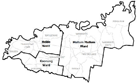
Locations at risk of flooding include:
- Templestowe
- Templestowe Lower
- Bulleen
- Doncaster
- Doncaster East
- Warrandyte
Manningham Local Flood Guide
This guide is relevant for residents of
|
Click the button below to view the Local Flood Guide, which includes information about the local flood risk and how you can prepare for and respond effectively to floods.
Manningham Council Flood and Storm Emergency Plan
Municipalities can use Municipal Flood and Storm Emergency Plans to prepare, respond and recover from flood and storm events.
Click the button below to view the Municipal Flood and Strom Emergency Plan.
About Flood Guides
Communities can use local flood guides to identify and better understand their local flood risk. They include information about: flood history, how to prepare & respond to floods and who to contact.
Contact Information


Local SES Units
- Manningham VICSES Unit:
Corner of Blackburn and Warrandyte Roads, Doncaster East, Victoria
Municipal Flood and Storm Plan
Manningham Storm and Flood Emergency Plan - Updated July, 2020.