Mansfield Shire Council

Flood information for the Mansfield Shire Council, encompassing local flood guides and a Municipal Flood Emergency Plan.
On this page:


Mansfield Shire Council municipal map
 Mansfield Shire Council municipal map - click to enlarge.

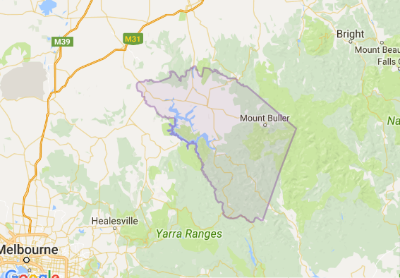
Mansfield Shire sits in the upper Goulburn catchment, which collects rainfall from Woods Point to Mount Skene and the western end of the Alpine National Park.

Mansfield Shire can experience both riverine and flash flooding. Riverine flooding typically occurs when the Goulburn or Jamieson Rivers (or both) break their banks and overflow after heavy or prolonged rainfall in the steep catchments of the surrounding state forests and Alpine National Park.

Flash flooding can occur at any time of year during and after heavy rain or thunderstorms. The hilly terrain makes flash flooding more likely as water can gain both speed and power as it flows downhill.

Flash flooding in September 2010 caused the largest recorded flood in the Jamieson area with 27 properties and the Jamieson caravan park flooded. This flood peaked soon after midnight, dropping away early the following morning.

Are you at risk of flood?


Jamieson expected flood guide map.
  Click to enlarge.

Jamieson can experience both riverine and flash flooding. Riverine floods in Jamieson happen when the Goulburn or Jamieson Rivers (or both) break their banks and overflow after heavy or prolonged rainfall in the steep catchments of the surrounding state forests and Alpine National Park.

Riverine flooding in Jamieson generally lasts about 24 hours, but in lowlying areas can take up to 48 hours to recede. The Jamieson Caravan Park and low-lying farms and rural properties are often impacted during flooding.

Flash flooding can occur in Jamieson at any time of year during and after heavy rain or thunderstorms. The hilly terrain surrounding Jamieson makes flash flooding more likely as water can gain both speed and power as it flows downhill.

Flash floods often come and go in just a few hours but can be deep, powerful, and fast-moving, making them very dangerous.

There is often little or no time to warn communities before flash flooding occurs. The Jamieson district is very remote. The Mansfield - Woods Point Road is the only main road in and out of town. Many places along this road can be flooded, closing the road both north and south of the town. Because of this, residents, visitors, campers, fishers, hunters and four wheel drivers can become isolated as roads and bridges become impassable.

Roads, bridges and tracks can also be damaged and blocked by landslides caused by prolonged rainfall. The impact of flooding on the Jamieson community can vary depending on the amount of rainfall, how quickly it has fallen and where it has fallen.

Past floods in Jamieson have resulted in nearly 30 properties being inundated (flooded above floor level), cut off by road closures or surrounded by floodwater.

The map to the right shows the expected flooding in a 1% flood in Jamieson. A 1% flood means that there is a 1% chance of a flood measuring 5.33m on the Doherty’s gauge on the Goulburn River in any given year.

About Flood Guides

Communities can use local flood guides to identify and better understand their local flood risk. They include information about: flood history, how to prepare & respond to floods and who to contact.

Contact Information

For more information, contact the North East Region.
For information on flood warnings, see the VicEmergency website.
Visit the Mansfield Shire Council website.
Your local Catchment Management Authority: Goulburn Broken.

Local VICSES Unit

Mansfield VICSES Unit:
Maroondah Highway,
Mansfield, 3722

Municipal Flood Emergency Plan (MFEP)

Mansfield Shire Council Flood Emergency Plan -  (coming soon)