Moira Shire Council

Flood information for the Moira Shire Council, encompassing local flood guides and a Municipal Flood Emergency Plan.

On this page:


Moira municipal map
Moira municipal map.

Moira Shire has a long history of flooding including the record-breaking flood event in 2012 which impacted most townships and vast areas of rural farmland resulting in extensive flood damage across the municipality.

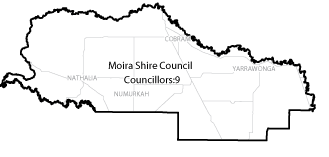
Moira Shire is located within and area bordered by the Warby Ranges to the east, the lower Dookie Hills lie alongside part of the southern boundary with the Murray River to the north, and several river floodplains and basins to the west.  Moira Shire’s main waterways include the Murray, Goulburn and Ovens Rivers, the Broken and Boosey Creeks and the Muckatah Depression.

Flooding within the Moira Shire generally happens as a result of very heavy rainfall, such as in 2012 or from sustained rainfall over a number of days such as in the 1993 flood.  

Are you at risk of flood?


Katamatite flood map
  Click to enlarge. 

The Katamatite area is located on a floodplain which can result in widespread flooding.

Katamatite is at risk of riverine flooding (overflowing of rivers and creeks) from the Boosey and Broken Creek catchments after prolonged rain (possibly in far-distant areas).

The area is also at risk of flash flooding after heavy local rain falling over a short period of time. The type and effect of flooding depends on the conditions of the catchment, including how much water is already in the ground and creeks.

Depending on the size of the flood, areas to the east and south of town are most vulnerable, including low-lying parts of Beek Street (Benalla-Tocumwal Road), Hotchin Street and Cemetery Road. The Katamatite Recreation Reserve likely to be inundated.

During a flood, the following main roads are likely to be closed in and around Katamatite:

  • Benalla – Tocumwal Road (Beek Street closed both north and south of town).

  • Katamatite - Nathalia Road, also known as Shepparton - Katamatite Road.

  • Katamatite - Yarrawonga Road.

The map to the right shows the likely spread of flooding in a 1% flood. A 1% flood means that there is a 1% chance of a flood this size occurring in any year. 

Are you at risk of flood?
 

Flooding in the Nathalia area can happen when:

Nathalia flod map
  Click to enlarge.
  • Floodwater overflows the banks of the Broken Creek.

  • Heavy local rainfall overwhelms local creeks and drains, especially from the Tungamah, Katamatite, Numurkah and Wunghnu area.

  • Floodwater from the Benalla area breaks out from the Broken River at Casey’s Weir and/or Gowangardie Weir, flowing overland toward the Broken Creek near Walsh’s Bridge.

During major level floods, the flat nature of the area usually results in slow-moving floods that last around ten days, with low-lying areas outside the levee taking longer to clear. Important roads are likely to be closed including the Murray Valley Highway and roads to Shepparton, Katamatite, Waaia and Echuca.

Isolation is likely for parts of the town and most surrounding rural properties. Properties outside the town levee are at high risk of overfloor flooding and/ or isolation, including (but not limited to) low areas of Lancaster Avenue, McCarrons Road, Ryan’s Road and Cemetery Road. Levees are designed to reduce the risk of flooding, not to protect people.

During minor floods, roads, levees and channels can usually cope with most of the floodwater. No levee is guaranteed flood proof. Levees can and do fail; during large floods, failure of any part of the town levee could result in flooding of most of the town to over one metre deep.

The map to the right shows the 2012 flood which measured 3.26 metres on the Nathalia Town Gauge in and around Nathalia.

Are you at risk of flood?

Flooding in the Numurkah area can happen when:

Numurkah Flood map
Click to enlarge.
  • Floodwater from heavy rainfall in the upper catchment overflows the banks of the Broken creek.
  • Heavy local rainfall overwhelms local creeks and drains, such as the 2012 record-breaking rainfall. The reason for this flood moving so quickly was that heavy rain fell twice in a week and the sheer volume of runoff from rain that fell in both the wider catchment and the local area.

During large floods, the flat nature of the area and its location on the floodplain means isolation is likely for Numurkah and surrounding low-lying rural properties. Large flood events usually take more than a week to pass Numurkah with low-lying areas taking longer to clear and may increase damage to the area.

Areas of the town that may be affected during large floods include those south of the Broken Creek and East of Kinnairds Road. Major roads can be closed including the Goulburn Valley Highway, Katamatite-Nathalia Road and most roads across the Muckatah Depression and the Broken and Boosey floodplains.

From the 1990s to mid-2000, a community surface drain scheme was implemented in the Muckatah Depression to help remove excess water from minor storm runoff and to slow and reduce water flows into the Broken Creek.

During floods caused by heavy local rainfall however, floodwater spills out of the drains and spreads across the natural flow path of the Muckatah Depression floodplain.

Are you at risk of flood?

Tungamah flood map
  Click to enlarge.

Tungamah has a history of flooding, usually from the Boosey Creek after heavy rainfall in the upper Boosey Creek catchment.

This catchment is bound to the south by Winton Wetlands, to the north by the Muckatah Creek, to the west by the Broken Creek and to the east by the Warby Ranges.

The type and effect of flooding that will impact Tungamah depends on the conditions of the Boosey Creek catchment, including how wet the ground already is and how full the creeks are when rainfall occurs.

The February/March 2012 flash flood occurred when 300 millimetres (many local gauges measured much more) of rain fell in the area over three days. There is no warning system in Tungamah, and so residents did not have any time to prepare before parts of the township were heavily inundated.

When the Boosey Creek floods it spills over in many places including over roads. During floods, major roads closed in the area include:

  • Devenish Road

  • Tungamah Road

  • Tungamah Main Road

Based on previous flood history, there will be limited access to the community centre in Barr Street, football and netball recreation reserve, Jubilee Park and access to the local pub during a flood.

The map to the right shows the possible impact of a 1% flood from Boosey Creek. A 1% flood means that there is a 1% chance of a flood occurring in any given year. A 1% flood in Tungamah measures about 2.90 metres on the Tungamah Station Gauge.

About Flood Guides

Communities can use local flood guides to identify and better understand their local flood risk. They include information about: flood history, how to prepare & respond to floods and who to contact.

Contact Information

For more information, contact the North East Office - Benalla.
For information on flood warnings, see the VicEmergency website.
Visit the Moira Shire Council website.
Your local Catchment Mangement Authority: Golbourn Broken.

Local VICSES Units

  • Cobram VICSES Unit:
  • Jerilderie Street, Tocumwal, New South Wales
  •  
  • Numurkah VICSES Unit:
  • Nelson Street, Numurkah, Victoria
  •  
  • Yarrawonga VICSES Unit:
  • cnr Dunlop and Woods Roads, Yarrawonga, Victoria

Municipal Flood Emergency Plan (MFEP)

Municipalities can use Municipal Flood Emergency Plans to prepare, respond and recover from flood and storm events.

Moira Shire Flood Emergency Plan - Updated Dec, 2020.