


Flood information for the Merri-bek City Council (Moreland City Council), encompassing local flood guides and a Municipal Flood Emergency Plan.
Merri-bek City Flood History
Merri-bek City Council has a history of flooding (riverine and flash flooding) including a significant flood event in 2005. Other significant flood events have occurred in 1916, 1934, 1946, 1952, 1954, 1963, 1974, 1977, 1987 and 1989.
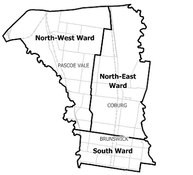
Locations at risk of flooding include:
-
Glenroy
-
Pascoe Vale
-
Hadfield
-
Fitzroy North
-
Fawkner
-
Coburg North
-
Coburg
-
Gowanbrae
-
Oak Park
-
Brunswick East
-
Brunswick West
Merri-bek Local Flood Guide
Merri-bek City Council Flood and Storm Emergency Plan
Municipalities can use Municipal Flood and Storm Emergency Plans to prepare, respond and recover from flood and storm events.
Click the button below to view the Municipal Flood and Strom Emergency Plan.
About Flood Guides
Communities can use local flood guides to identify and better understand their local flood risk. They include information about: flood history, how to prepare & respond to floods and who to contact.
Contact Information


Local SES Units
- Fawkner VICSES Unit:
1161 Sydney Road, - Hadfield VIC3046
Municipal Flood and Storm Plan
City of Merri-bek Flood and Storm Emergency Plan - Updated November, 2024