


Flood information for the South Gippsland Shire Council encompassing local flood guides and Municipal Flood and Emergency Plan.
South Gippsland Shire Council Flood History
There have been a number of significant flood events in South Gippsland including in 1934, 1990,
March 2011, May 2012 and June 2012. These events have caused significant infrastructure and property damage, as well as tragically the loss of lives.
The area is characterised by steep ranges to the north which contain the headwaters of a number of waterways in the Shire, and the slopes that run through the region result in patches of rolling hills and steep farmland. Other areas in South Gippsland are very flat, especially near the coast, where the lowlands extend for many kilometres.
The predominant riverine flooding risk is on the Tarwin River at Tarwin Lower, Fish Creek and Meeniyan and associated rural areas.
Short duration, high intensity rainfall (usually associated with thunderstorms) can cause flash flooding throughout South Gippsland.
The lead time to respond to a flood event may be limited. All households and businesses at risk of flooding should develop an emergency plan and beware of their flood risk.
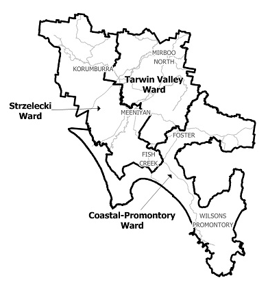
Tarwin Valley Local Flood Guide
This guide is relevant for residents of
|
Click the button below to view the Local Flood Guide, which includes information about the local flood risk and how you can prepare for and respond effectively to floods.
South Gippsland Shire Council Flood and Storm Emergency Plan
Municipalities can use Municipal Flood and Storm Emergency Plans to prepare, respond and recover from flood and storm events.
Click the button below to view the Municipal Flood and Strom Emergency Plan.
About Flood Guides
Communities can use local flood guides to identify and better understand their local flood risk. They include information about: flood history, how to prepare & respond to floods and who to contact.
Contact Information


West Gippsland.
Local SES Units
- Leongatha VICSES Unit:
- 12 Watson Rd,
- Leongatha
- Foster VICSES Unit:
- 14 Pioneer St,
- Foster VIC 3960
Municipal Flood and Storm Plan
South Gippsland Shire Council Flood and Storm Emergency Plan - Updated August, 2022.