


Flood information for the Towong Shire Council, encompassing local flood guides and a Municipal Flood Emergency Plan.
Towong Shire Council Flood History
Towong Shire Council has a history of flooding including significant flood events in January 2012 and 2010, which impacted the townships of Walwa and Jingellic.
Floods in this area have often destroyed or damaged roads and bridges. Large trees and plant debris regularly block waterways. When these blockages give way, this can create powerful surges of water and unexpected rises in river levels.
Flash floods from steep mountain creeks often flood roads such as Murray River Road in Victoria, isolating valley communities, and camping areas. Major settlements in the Upper Murray area are above the Murray River floodplain, however high river levels in the Murray River can cause floodwater to back up into surrounding creeks resulting in longer periods of high water, or even second flood peaks. This can also cause isolation and increase damage to local areas.
The lead time to respond to a flood event may be limited. All households and businesses at risk of flooding should develop an emergency plan and beware of their flood risk.
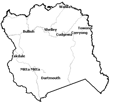
Upper Murray Local Flood Guide
This guide is relevant for residents of
|
Click the button below to view the Local Flood Guide, which includes information about the local flood risk and how you can prepare for and respond effectively to floods.
Upper Murray LFG Supplement - Guide to the Gauges
There are eight river height gauges along the Murray River and its rivers and creeks in the Upper Murray area (see link below). River gauges monitor river levels and may be used in flood warnings and information. Some river gauges have flood class levels of minor, moderate and major set and can provide a prediction of flood heights expected, while others show height in metres (m).
Towong Shire Council Flood and Storm Emergency Plan
Municipalities can use Municipal Flood and Storm Emergency Plans to prepare, respond and recover from flood and storm events.
Click the button below to view the Municipal Flood and Strom Emergency Plan.
About Flood Guides
Communities can use local flood guides to identify and better understand their local flood risk. They include information about: flood history, how to prepare & respond to floods and who to contact.
Contact Information


North Eastern.
Local SES Units
- Mitta Mitta VICSES Unit:
1793 Mitta North Rd,
Mitta Mitta.
Corryong VICSES Unit
13 Jardine Street, Corryong.
Tallangatta VICSES Unit
7 Wagara Street, Tallangatta.
Municipal Flood and Storm Plan
Towong Shire Council Flood Emeregncy Plan – Updated June, 2023.