


West Wimmera Shire Council Flood History
West Wimmera Shire Council has towns that are subject to stormwater and riverine flooding. Towns that are prone to stormwater flooding include Apsley and Edenhope.
Flood events within West Wimmera have been infrequent over the last decade. The most recent flood event was recorded in 2016.
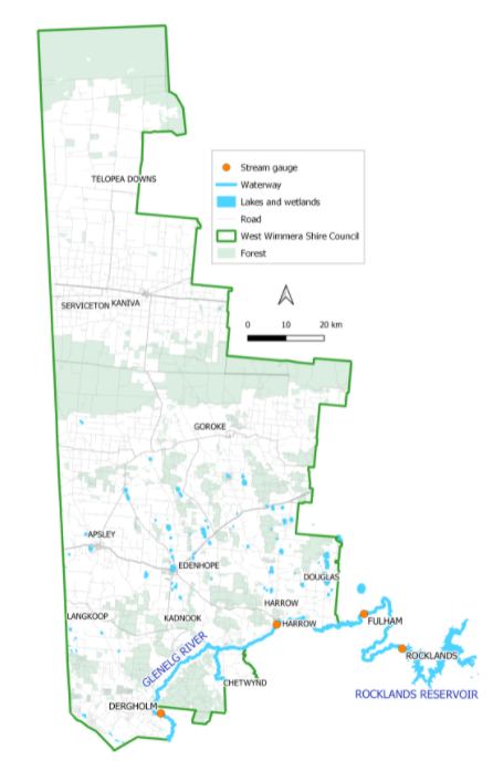
The Shire has three major waterways that impact various townships, localities and the rural areas. They are the Glenelg River (including Salt Creek), The Chetwynd River and the Koijak Creek.
These systems flow in or near to towns within the Municipality. Lake Wallace at Edenhope is the largest body of water in the Shire.
Predominantly two townships are impacted within the Shire from flooding events - Apsley and Harrow. The township of Harrow has experienced two large flood events within the last 10 years, with the flood in 2010 being the largest recently recorded event.
Apsley has had numerous smaller events, predominately due to rainfall and water not draining away as quick as other areas. Within the West Wimmera Shire rural flooding can be significant, other townships do experience some flooding during large flood events within the region.
Harrow Local Flood Guide
West Wimmera Shire Council Flood and Storm Emergency Plan
Municipalities can use Municipal Flood and Storm Emergency Plans to prepare, respond and recover from flood and storm events.
Click the button below to view the Municipal Flood and Strom Emergency Plan.
About Flood Guides
Communities can use local flood guides to identify and better understand their local flood risk. They include information about: flood history, how to prepare & respond to floods and who to contact.
Contact Information


Local SES Units
- Edenhope Unit:
- 26 Mollison Street,
- Edenhope, Victoria 3318
- Goroke Unit:
- 4 Barrack Street,
- Goroke, Victoria, 3412
- Kaniva Unit:
79 Commercial Street,
Kaniva, Victoria, 3419
Municipal Flood and Storm Plan
Municipalities can use Municipal Flood and Storm Plans to prepare, respond and recover from flood and storm events.
West Wimmera Flood Emergency Plan - Updated Feb, 2020.