Gannawarra Shire Council

Flood information for the Gannawarra Shire Council, encompassing local flood guides and a Municipal Flood Emergency Plan.
On this page:


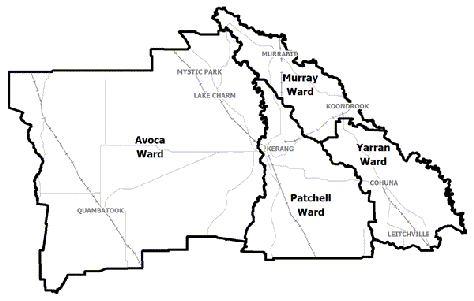
Gannawarra Municipal map
Gannawarra Shire municipal map.

Gannawarra Shire Council has a history of flooding including a significant flood event in January 2011 which impacted the townships of Qumabatook and Kerang and vast extents of rural areas resulting in extensive damage.

The two key river systems which impact the Gannawarra Shire areas are the Loddon River and the Avoca including the January 2011 events and the 1983 event.

Households and businesses should refer to the Local Flood Guide or the Gannawarra Shire Flood Emergency Plan  for more information.

Are you at risk of flood?

Kerang flood guide map
 Click to enlarge

Due to the flat nature of the landscape and its close proximity to the Loddon River, Kerang and itssurrounding areas are vulnerable to overland flows of water.

Within the Loddon catchment there are a number of creeks and river run offs. Significant floods have been recorded in Kerang in 1909, 1916, 1933, 1975, 1981, 1993 and 2011.

The 2011 flood followed an extensive period of wet weather with major flooding through the lower Loddon and Avoca Rivers in September, December 2010 and September 2016.

Widespread flooding in Kerang led to a number of mitigation works in the area during 1980-1996 to help reduce the impact of floods. Kerang’s levees run for 17 kilometres and include part of the Murray Valley Highway to the south of the town. Properties start to become isolated to the north and south of Kerang when the Murray Valley Highway Bridge Gauge reads 77.20 metres, just above minor flood level of 77.00 metre.

During the 2011 flood, floodwater overtopped the Pyramid Creek levee. However, the township of Kerang was saved from the full extent of the flooding by a combination of the levee on the Loddon River and a temporary levee built on the southern side of Kerang.

Kerang’s levees have reduced the level of risk associated with flooding in some areas of the town, however no levee is flood proof and some houses and businesses inside and outside of the town were flooded. 

The map to the right shows the extent of the January 2011 flood which measured 78.03m on the Murray Valley Highway River Gauge.

Are you at risk of flood?

Murrabit and Benjeroop Local Flood Guide map
Click to enlarge.

Murrabit and Benjeroop are located on the lower Loddon River floodplain near the Murray River. The chance of flooding increases when both the Loddon and the Murray Rivers are in flood at the same time.

Major flooding of the Avoca River can also contribute to flooding of the Lower Loddon floodplain area. Significant flooding has occurred throughout the region since settlement, and property owners have constructed a series of earthen levees throughout the floodplain over the last hundred years. Many of these levees are in poor condition, are located on private land and cannot be relied on to protect from riverine flooding.

Murrabit township is located on higher ground, and is protected by a series of levees; however extensive rural areas around the township including Benjeroop are at risk of extensive and long term inundation.

No levee is flood proof, including the many levees built on private land. It is likely that large parts of the district will be inundated in future flood events.

The map to the right shows the extent of flooding in the area during the 2011 flood event and the expected flooding from a 1% Annual Exceedance Probability (AEP) flood of the Murray River.


Are you at risk of flood?

Quambatook Local Flood Guide map
  Click to enlarge. 

Quambatook is at risk of flooding from the Avoca River, and is also vulnerable to flash flooding
caused by heavy rainfall over a short period of time.

Although the township of Quambatook is built on higher ground and has levees providing some protection, large floods can still cause damage within the township and no levee is guaranteed flood proof.

During the January 2011 flood event approximately three kilometres of temporary earthen levees were constructed by Council with considerable local voluntary effort.

If the temporary levees had not been constructed most of the 120 houses and shops in town would have been flooded.

Since the river gauge was installed at Quambatook South in 1963, there have been 17 recorded flood events above the minor flood level. These events were generally limited to agricultural land and required the occasional closure of minor roads.

On 9 January 2011, after 100mm of rain fell in a few hours, water overwhelmed the town’s drainage which caused flash flooding in parts of the township. Although levees and floodways assist in protecting the Quambatook township, these levees are only designed to protect property and cope with a certain flood level.

Floods in excess of the Major flood level may result in water overflowing the levees and floodways, flooding the town. This was prevented in 2011 when temporary levees were constructed on the eastern side of town. No levee is guaranteed flood-proof. If flooding affects Charlton, then it typically affects Quambatook 40-96 hours later.

The map to the right shows the extent of flooding in the January 2011 and September 1983 floods as well as the location of the temporary levees built by Council and the local community.

About Flood Guides

Communities can use local flood guides to identify and better understand their local flood risk. They include information about: flood history, how to prepare & respond to floods and who to contact.

Contact Information

For more information, contact the North West (Loddon Mallee).
For information on flood warnings, see the VicEmergency website.
Visit the Gannawarra Shire Council website.
Your local Catchment Mangement Authority: North Central.

Local VICSES Unit

Kerang VICSES Unit
8 Tate Drive,
Kerang, Victoria.

Municipal Flood Emergency Plan (MFEP)

Municipalities can use Municipal Flood Emergency Plans to prepare, respond and recover from flood and storm events. Gannawarra Shire Council  Emergency Plan - Updated Dec, 2020