


Wellington Shire Council Flood History
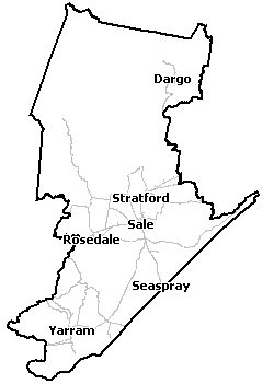
Wellington Shire Council is home to the Thomson, Macalister, Avon, Latrobe, Albert, Tarra and Mitchell Rivers, Merrimans Creek and the Gippsland Lakes. The Thomson Reservoir, Glenmaggie Weir and Cowwarr Weir are located in the Thomson / Macalister rivers and can impact flooding in areas below the reservoirs.
Weather systems commonly referred to as east coast lows can produce heavy rainfall on frequent occasions which can lead to minor riverine flooding with major flood events in both the rivers and lakes occurring more rarely.
For example, during June 2007, four major east coast lows occurred in succession with each one producing heavy rainfall. The last east coast low brought up to 300mm of rainfall resulting in major riverine flooding across the Council area and the Gippsland Lakes rising 1.3m above normal levels.
A significant risk is isolation of communities, vehicles and recreational visitors through the area when rivers and creeks rise making roads impassable.
Households and businesses should refer to their Local Flood Guide or East Gippsland Shire Flood Emergency Plan for more information.
Boisdale and Bushy Park Local Flood Guide
Click the button below to view the Local Flood Guide, which includes information about the local flood risk and how you can prepare for and respond effectively to floods.
Briagolong Local Flood Guide
Click the button below to view the Local Flood Guide, which includes information about the local flood risk and how you can prepare for and respond effectively to floods.
Coongulla and Glenmaggie Local Flood Guide
Click the button below to view the Local Flood Guide, which includes information about the local flood risk and how you can prepare for and respond effectively to floods.
Dargo Local Flood Guide
Click the button below to view the Local Flood Guide, which includes information about the local flood risk and how you can prepare for and respond effectively to floods.
Gippsland Lakes Local Flood Guide
Click the button below to view the Local Flood Guide, which includes information about the local flood risk and how you can prepare for and respond effectively to floods.
Hollands Landing Local Flood Guide
Licola Local Flood Guide
Loch Sport Local Flood Guide
Maffra Riverslea and Bundalaguah Local Flood Guide
Newry and Tinamba Local Flood Guide
Click the button below to view the Local Flood Guide, which includes information about the local flood risk and how you can prepare for and respond effectively to floods.
Rosedale Local Flood Guide
Sale Local Flood Guide
Seaspray Local Flood Guide
Stratford Local Flood Guide
Valencia Creek Local Flood Guide
About Flood Guides
Communities can use local flood guides to identify and better understand their local flood risk. They include information about: flood history, how to prepare & respond to floods and who to contact.
Contact Information


West Gippsland.
Local SES Units
- Sale Unit:
37-37 Union Street,
Sale, Victoria 3850 - Stratford Unit:
53 McFarland Street,
Stratford, Victoria, 3862 - Maffra Unit:
90 Landy Street,
Maffra, Victoria, 3860 - Yarram Unit:
Railway Avenue,
Yarram, Victoria, 3971 - Rosedale Unit:
47 Cansick Street,
Rosedale, Victoria, 3847 - Loch Sport Unit:
National Parks Road,
Loch Sport, Victoria, 3851
Municipal Flood and Storm Plan
Municipalities can use Municipal Flood and Storm Plans to prepare, respond and recover from flood and storm events.
Wellington Shire Municipal Flood Emergency Plan - Updated June, 2016.
This municipal flood and storm plan is currently being updated. The revised and updated plan will be available soon.