Yarriambiack Shire Council

Flood information for Yarriambiack Shire Council, encompassing local flood guides and a Municipal Flood Emergency Plan.

On this page:
Yarriambiack municipal council map.
  Yarriambiack municipal council map.

Click on the map to view the location map of Dunmunkle Creek, Yarriambiack Creek and Wimmera River in relation to towns impacted. 

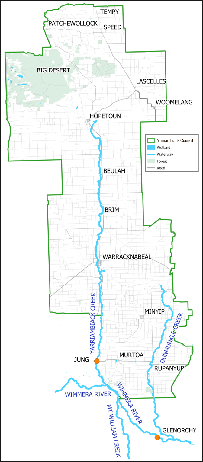
Yarriambiack Shire has a history of flooding, including the most significant recent flood event in 2011 which recorded widespread riverine and stormwater flooding throughout the Yarriambaick Shire region. 

The highest number of buildings impacted by flooding was recorded in Rupanyup and Warracknabeal. Although minor flood impacts were felt in Brim, Beulah and Hopetoun, a significant number of houses were isolated during this event. As a result theree was widespread damage to roads, crops, stock losses and other community assets along Yarriambiack and Dunmunkle creeks.

There is significant lead time during riverine flood events, for Rupanyup 1 to 3 days and Warracknabeal 3 to 5 days after the Wimmera River stream gauge peaks at Glenorchy.

Towns such as Warracknabeal and Rupanyup are also heavily impacted by stormwater flooding, flooding from local rainfall.  During January 2011 damage to a significant number of buildings was caused by stormwater flooding in these towns. 
 

In Rupanyup over 149 mm fell over 3 days impacting the Rupanyup Café, and buildings in Cromie, Stewart, Edward, Gibson, Walter, Gordon and Beryl Streets. In Warracknabeal more than 151 mmm over 5 days impacting houses in Lyle Street, Gardiner Street, McIntyre Street, Asquith Reserve and the Borung Highway (east of the Racecourse).


Source: https://wcma.vic.gov.au/publications-resources/
Jung stream gauge height (m) Warracknabeal flood extent map links
2.39

https://wcma.vic.gov.au/wp-content/uploads/2022/05/warracknabeal-and-brim-2016-200yr-ari-or-0-5-aep-warracknabeal-brim.pdf?sfvrsn=58a86768_2

2.3

https://wcma.vic.gov.au/wp-content/uploads/2022/05/warracknabeal-and-brim-2016-100yr-ari-or-1-aep-warracknabeal-brim.pdf?sfvrsn=4aa86768_2

2.17

https://wcma.vic.gov.au/wp-content/uploads/2022/05/warracknabeal-and-brim-2016-50yr-ari-or-2-aep-warracknabeal-brim1b44006fdfec67aca7a3ff00001883ab.pdf?sfvrsn=3ba86768_2

1.2

https://wcma.vic.gov.au/wp-content/uploads/2022/05/warracknabeal-and-brim-2016-20yr-ari-or-5-aep-warracknabeal-brim.pdf?sfvrsn=93ad6768_2

0.95

https://wcma.vic.gov.au/wp-content/uploads/2022/05/warracknabeal-and-brim-2016-10yr-ari-or-10-aep-warracknabeal-brim.pdf?sfvrsn=bfad6768_2

0.84

https://wcma.vic.gov.au/wp-content/uploads/2022/05/warracknabeal-and-brim-2016-5yr-ari-or-20-aep-warracknabeal-brim.pdf?sfvrsn=a9ad6768_2


Other Links


Are you at risk of flood?

The Wimmera River directly impacts flooding of Yarriambiack Creek. During moderate to major

Warracknabeal LFG map
  Click to enlarge.

floods, the Wimmera River spills over into the Yarriambiack Creek which then flows to the north, impacting on towns and properties along the creek.

Since flooding in 2011, the Warracknabeal community, Yarriambiack Shire Council and the Wimmera Catchment Management Authority have developed plans to construct a levee to protect the town from future flooding.

Although it is recognised that no two flood events are the same, the proposed levee aims to provide protection for up to 157 houses in Warracknabeal during major floods similar to those experienced in 2011.

Warracknabeal also experiences large areas of stormwater flooding when very heavy rainfall overwhelms the town drainage system., with Tarrant, Woolcock and Molyneaux Streets, and areas around the old railway station particularly vulnerable to inundation.

Warracknabeal Flood Risk Information Card.pdf

Are you at risk of flood?

Rupanyup flood map
Rupanyup flood map - click to enlarge

Rupanyup is impacted by both riverine flooding from Dunmunkle Creek and stormwater flooding from local rainfall. Flooding in the Dunmunkle Creek is driven by high flows in the Wimmera River.

Rupanyup and Dunmunkle Creek has experienced flooding in 1909, 1916, 1956, 1974, 1975, 1992, 1993, 2010, 2011 and 2016.The largest recent flood event on record was the January 2011 flood event. During this event Rupanyup was significantly impacted by both riverine and stormwater flooding.

Riverine flooding from Dunmunkle Creek began to rise on Sunday the 16th and peaked on Monday the 17th of January. Local reports indicate that 18 buildings were at risk of flooding. Due to sandbagging only seven buildings were flooded above floor these included the old Rupanyup supermarket, Bendigo Bank, Rupanyup Bowels Clubrooms, and the public toilets in Cromie Street. Flooding significantly impacted low lying farmland along Dunmunkle Creek. Flooding cut access to most of the roads and crossings along Dunmunkle Creek and caused significantly damage to infrastructure within Rupanyup and along Dunmunkle Creek.

Roads impacted in Rupanyup include the Wimmera Highway, Stawell-Warracknabeal Road, Dyer Street, Boyds Road, Connolly Parade, Walter Street, Taylor Street, Wood Street, Cromie Street, Stewart Street, Westcott Avenue, SimpsonAvenue, Gibson Street, Ron Lingham Drive and McIntyres Road.

Historic flood events show that flood travel times between Glenorchy and Rupanyup can take between 28 hours to 123 hours. Flood levels along Dunmunkle Creek in Rupanyup may be high for 2 to 3 days.

Glenorchy stream gauge information


About Flood Guides

Communities can use local flood guides to identify and better understand their local flood risk. They include information about: flood history, how to prepare & respond to floods and who to contact.

Contact Information

For more information, contact the Mid West (Grampians) Region Headquarters.
For information on flood warnings, see the VicEmergency website. 
Visit the Yarriambiack Shire Council website.
Your local Catchment Mangement Authority: Wimmera.

Local VICSES Units

  • Warracknabeal VICSES Unit
    19 Lyle Street,
    Warracknabeal, VIC 3393

  • Dunmunkle VICSES Unit
    2 Wood Street,
    Rupanyup, VIC 3388

  • Woomelang VICSES Unit
    6509 Berriwoolock-Woomelang Road, Woomelang, VIC 3485 

Municipal Flood Emergency Plan (MFEP)

Municipalities can use Municipal Flood Emergency Plans to prepare, respond and recover from flood and storm events.
Yarriambiack Shire Council Flood Emergency Plan - Updated Feb, 2020.