


Flood information for the Moyne Shire, encompassing local flood guides and a Municipal Flood Emergency Plan.
Moyne Shire Flood history
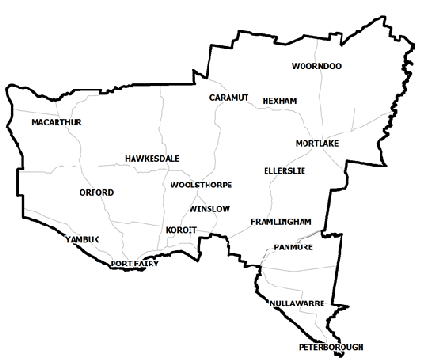
The Moyne catchment has historically been subject to significant flooding including a major flood in 2010 that resulted in the sewage station needing to be sandbagged for protection. Sand dunes at the end of the airport were breached and several roads and bridges closed.
Households and business should refer to their Local Flood Guide or Moyne Shire Municipal Flood Emergency Plan for more information.
Peterborough
Peterborough is impacted by both riverine and coastal flooding. The Curdies River Estuary is predominantly shaped by the prevailing south westerly ocean swell causing infilling and is classified as a wave dominated estuary.
The rocky headland to the west of the estuary combined with easterly currents, common in summer months, promotes the accumulation of sand at the estuary entrance forming sandbars.
Port Fairy Local Flood Guide
Moyne Shire Flood and Storm Emergency Plan
Municipalities can use Municipal Flood and Storm Emergency Plans to prepare, respond and recover from flood and storm events.
This document is currently under review.
About Flood Guides
Communities can use local flood guides to identify and better understand their local flood risk. They include information about: flood history, how to prepare & respond to floods and who to contact.
Contact Information


Local SES Units
- Port Fairy VICSES Unit:
81 Sackville Street,
Port Fairy, Victoria
Mortlake VICSES Unit:
4 Stewart St,
Mortlake Victoria,
Municipal Flood and Storm Plan
Moyne Shire Emergency Managament Plan - Document currently under review.