East Gippsland Shire Council

Flood information for the East Gippsland Shire Council, encompassing local flood guides for Lakes Entrance, Eagle Point, Metung, Paynesville and Raymond Island as well as the East Gippsland Shire Municipal Flood and Emergency Plan.

On this page:

East Gippsland is home to the Genoa, Cann, Bemm, Tambo, Nicholson, Snowy, Buchan and 

East Gippsland municipal map
East Gippsland municipal map.


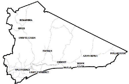
Mitchell Rivers and the Gippsland Lakes. Weather systems commonly referred to as East Coast Lows can produce heavy rainfall on frequent occasions which can lead to minor riverine flooding with major flood events in both the rivers and lakes occurring more rarely.

For example, during June 2007, four major east coast lows occurred in succession with each one producing heavy rainfall.  The last east coast low brought up to 300mm of rainfall resulting in major riverine flooding across the Council area and the Gippsland Lakes rising 1.3m above normal levels.

A significant risk is isolation of communities, vehicles and recreational visitors through the area when rivers and creeks rise, landslips and falling vegetation make roads impassable. Storms can also cause power and communication outages simultaneous to flooding.

Are you at risk of flood? 
 

Bruthen to Swan Hill flood map
  Click to enlarge.

The Tambo River runs downstream from Bruthen, passing through several small townships including Mossiface, Tambo Upper, Bumberrah, Swan Reach and Johnsonville/Tambo Estate, before flowing into Gippsland Lakes at Lake King, west of Metung.

Many properties and roads are at risk of being inundated from high floodwaters, particularly those low on the floodplain.

When Tambo River floods, water quickly begins to pool in the floodplain south of Bruthen and the depth of floodwater increases as water builds up downstream.

Relatively small floods result in water spilling into the old Tambo River watercourse, which reconnects to Tambo River just over a kilometre north of Fred Albert Bridge (Stephenson Road, Tambo Upper)

Are you at risk of flood?

Eagle point flood map
  Click to enlarge.

The Gippsland Lakes have a history of flooding. In Eagle Point, low-lying community infrastructure such as boat ramps, car parks and jetties are impacted by flooding from both the Mitchell River and Gippsland Lakes.

Boat ramps, jetties and car parks flood early which can cause unwary boat owners to return and find their cars flooded.

Properties along the Mitchell River Silt Jetties are generally isolated early due to high velocity flows from the Mitchell River.

The properties most at risk are on Rivermouth Road on the Silt Jetties between the Mitchell River and Lake King, and those facing Lake King along Bay Road. Boats in marinas and jetties will need their mooring lines adjusted as the lake heights build and recede.

The map to the right shows likely flooding at the Minor Flood Level, the 2007 flood event and the effects of a 1% flood in Eagle Point. A 1% flood means there is a 1% chance of a flood this size occurring in any year.

Are you at risk of flood?

Lakes Entrance flood map
 Click to enlarge.

The Gippsland Lakes have a history of flooding. In Eagle Point, low-lying community infrastructure such as boat ramps, car parks and jetties are impacted by flooding from both the Mitchell River and Gippsland Lakes.

Boat ramps, jetties and car parks flood early which can cause unwary boat owners to return and find their cars flooded.

Properties along the Mitchell River Silt Jetties are generally isolated early due to high velocity flows from the Mitchell River.

The properties most at risk are on Rivermouth Road on the Silt Jetties between the Mitchell River and Lake King, and those facing Lake King along Bay Road. Boats in marinas and jetties will need their mooring lines adjusted as the lake heights build and recede.

The map above below shows the expected flooding for the Bruthen to Swan Reach area. A major flood event occurs at 10 meters on the Tambo River Ramrod Creek junction gauge, North East of Bruthen. This is what flooding would look like when experiencing a 1 in 100 year flood.

Are you at risk of flood?

metung flood map
Click to enlarge.

Flooding typically occurs in Metung one to three days after the Latrobe, Thomson, Macalister, Avon, Mitchell, Nicholson and/or Tambo Rivers have experienced flooding.

Flood peaks will slow to rise and fall, sometimes taking up to two weeks for floodwater to recede.

Wind can increase the lake levels around Metung by up to 50 centimetres. Metung and Tambo Bay are not at risk of large numbers of properties flooding, however some roads may be closed.

Properties on Shaving Point may have some flood impact where they front onto Lake King but flooding does not normally occur above floor level.

There are many marinas and jetties around Metung where boats will need their mooring lines adjusted to accommodate the rise and fall in lake height.

Access to Metung is via the Princes Highway and Metung Road. If Metung Road becomes impassable where it follows the Tambo River below Swan Reach, alternative access is via Nungurner Road.

The map to the right shows the Minor flood level (0.8 metres), the Major level (1.9 metres) and the 1% level, meaning there is a 1% chance of this kind of flood occurring each year.

Are you at risk of flood?

Paynesville flood map
Click to enlarge.

Flooding typically occurs in the Paynesville community one to three days after the Latrobe,Thomson, Macalister, Avon, Mitchell and/or Tambo Rivers have experienced flooding.

Flood peaks are slow to rise and recede, sometimes taking up to two weeks. Wind can increase lake levels around Paynesville by up to 50 centimetres.

Many parts of Paynesville are located above the flood level, however local road closures may require residents to seek alternative routes to Bairnsdale and create access problems to local shops and businesses.

Properties on Burrabogie Island and along Slip Road are the most at risk of isolation and over floor flooding.

In Paynesville there is low-lying community infrastructure such as boat ramps, car parks, and jetties that are impacted by flooding. Boats in marinas and on jetties will need their mooring lines adjusted as the lake heights build and recede.

The map to the right shows the 2007 flood extent, which was 1.5 metres, and the Minor Flood Level, which is 0.7 metres on the McMillan Straits at Paynesville Gauge.

Are you at risk of flood 

Raymond Island flood map
Click to enter.

Flooding typically occurs on Raymond Island one to three days after the Latrobe, Thomson,
Macalister, Avon, Mitchell, Nicholson and/or Tambo Rivers have experienced flooding.

Flood peaks are slow to rise and recede, sometimes taking up to two weeks. Wind can increase the lake levels around Raymond Island by up to 50 centimetres.

On Raymond Island there is low-lying community infrastructure such as boat ramps, car parks, and jetties that can be impacted by Gippsland Lakes flooding.

The Raymond Island Ferry stops operating at the Minor Flood Level resulting in isolation of the island which can last up to two weeks.

There are many homes and sheds in low-lying areas close to the water. These properties, along with local roads are subject to flooding at low levels. This in turn impacts on Raymond Island residents’ ability to travel within the island, causing properties to become isolated within the island. Boats in marinas and jetties will need their mooring lines adjusted as the lake heights build and recede.

The maps below show the 2007 flood extent, which was 1.5 metres at the McMillan Straits at Paynesville Gauge, and the Minor Flood Level which is 0.7 metres at the McMillan Straits at Paynesville Gauge.

Are you at risk of flood?

Over time the Snowy River has deposited large amounts of sediment in its channel and has developed natural perched levee banks sitting higher than the surrounding floodplain level.

The floodplain to the east and west of the Snowy (Bete Bolong and Jarrahmond, respectively), are highly susceptible to flooding, particularly the region downstream from Lynn’s Gulch (a low-point in the Snowy banks), where flows move toward Orbost.

Floodwaters in this region operate in two ways; the Snowy River overtops its banks during high flows, or during relatively small floods back-flooding occurs up ‘B drain’. The southern skirts of Orbost (below the Princes Hwy) are also highly prone to flooding due to the floodplain filling once Gilbert’s Gulch is overtopped.

Flood levels can be worsened due to two environmental phenomena:

  • High flows coming down the Brodribb River will raise water levels where it meets the Snowy River, causing a bottleneck of flows in the estuary.

  • East-coast low pressure systems generate high rainfall in the upper catchment area while often creating gale-force winds in Bass Strait which can raise storm-tide levels at the entrance. High tides and strong wave energy at the entrance reduces the ability for river flows to escape the estuary causing water to back up in the floodplain.

Several key roads may be cut by floodwaters affecting transport between neighbouring communities. These include Marlo Rd (under the Princes Hwy bridge and in several other locations between Orbost and Marlo), B Rd and Buchan-Orbost Rd (running parallel to the Snowy River from Orbost to Jarrahmond; lower Lochiel and Nicholson St (Orbost)), and Lochend Rd (running parallel to Snowy River toward Corringle).

  • Much of the natural levees along the riverbanks have been artificially built up and/or armoured to prevent erosion at critical points.

  • Please note, none of these levees were built or are maintained to current engineering standards – they therefore have the potential to fail unexpectedly at any time during a flood event.

Several floodgates exist to drain the floodplain of floodwaters while preventing backflow from the Snowy River, these are in Bete Belong, B Drain, Nixons, Newmerella and Icy Creek.

It should be noted however, that these structures are no longer actively maintained, and their effectiveness can’t be guaranteed during future floods.

Are you at risk of flood?

You may be at risk of being impacted by a flood in Bairnsdale if you live or work at a property situated low in the floodplain, or your require access through a road/bridge which is located near the river or lowlying floodplain.

Even areas far from the river may be at risk if the flood event is large enough to cause significant flooding. You should familiarise yourself with the following map and read further to understand key roads and areas which may be impacted.

Not every road or property can be listed, and it is important to be aware of your surroundings whenever the Bureau of Meteorology or VICSES have issued a flood warning.

  • The local Bairnsdale streamflow gauge will help you understand what areas may be impacted by floodwaters during an event. In general, you may have between 5 and 9 hours of warning time for peak flood waters to reach from the Glenaladale gauging station to Bairnsdale.

  • The Mitchell River bends around Bairnsdale and first breaks its banks at low-lying areas such as the Wy Yung Football oval, along the Mitchell River Walking Track, and at the east-end of Macleod St.

  • During moderate to major events, access to the Lind Bridge may be lost along Bullumwaal and Pound Swamp Hill Rd.

  • Floods measuring more than 6.8meters on the Bairnsdale gauge may cut access along Paynesville Rd, downstream from the Princes Highway bridge.

  • For larger and less frequent floods greater than 8.2 meters on the Bairnsdale gauge access along the Princes Highway Bridge at Bairnsdale may be lost due to flooding of the roads on approach to the bridge.

Impacts to property, buildings, roads, and features of interest, that may arise from various flood levels


About Flood Guides

Communities can use local flood guides to identify and better understand their local flood risk. They include information about: flood history, how to prepare & respond to floods and who to contact.

Contact Information

For more information, contact the Gippsland (East) Region Headquarters.
For information on flood warnings, see the VicEmergency website
Your local Catchment Mangement Authority: East Gippsland.

Local VICSES Units

  • Bairnsdale VICSES Unit
    Cnr Ligar and Macleod Streets,
  • Bairnsdale, Victoria 3875
  • Bendoc VICSES Unit
    9 Jamieson Street,
  • Bendoc, Victoria 3888
  •  
  • Bruthen VICSES Unit
    Main Street,
  • Bruthen, Victoria 3875
  •  
  • Buchan VICSES Unit
    Orbost Road,
  • Buchan, Victoria 3885
  • Cann River VICSES Unit
  • Monaro Highway, 
  • Cann River, Victoria 3890
  •  
  • Mallacoota VICSES Unit
    Lees Road, PO Box 493,
    Mallacoota, Victoria 3892
  •  
  • Orbost VICSES Unit
    5 Wolseley Street,
  • Orbost, Victoria 3888
  •  
  • Tambo Valley VICSES Unit
    Omeo Highway,
  • Swifts Creek,  Victoria  3896

Municipal Flood Emergency Plans (MFEP)

Municipalities can use Municipal Flood Emergency Plans to prepare, respond and recover from flood and storm events.
East Gippsland Municipal Flood Emergency Plan - Without Gippsland Lakes and
East Gippsland Municipal Flood Emergency Plan - Gippsland Lakes