Are you at risk of flood?
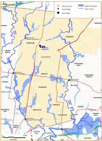
The City of Darebin is prone to flash flooding. Flash flooding occurs with little or no warning. It generally affects small areas but damage can be severe. It occurs after high intensity rainfall (usually associated with thunderstorms) and is short in duration. The Merri and Darebin Creeks may become flooded when there has been prolonged rainfall or due to flash floods.
The main flooding areas include the land or parks alongside the Merri and Darebin Creeks (including the Creek trails), as well as the A.H. Capp Reserve and the Northcote Golf Course. The Anderson Road Levee from Normanby Avenue to Miller Street in Thornbury, was built to protect Anderson Road, Newman Street, Strettle Street and the Merri Business Park from Merri Creek floodwaters. Darebin City Council has also constructed raingardens, and areas of porous pavement along several streets in Thornbury to slow down the flow of stormwater throughout the suburb.
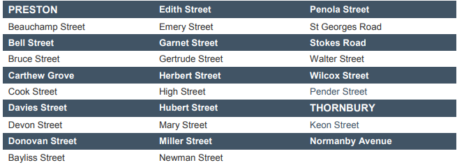
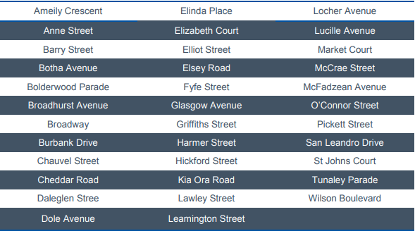
The increase in volume of water during high intensity, short duration rainfall events (e.g. more than 30 millimetres/hour) can still lead to flash flooding. Streets at risk of flooding in Thornbury should be avoided if flooding occurs. These include:
-
Ford Crescent
-
St Georges Road before it reaches Dundas Street
-
Bell Street between O’Keefe and Albert Street
-
The area around Station Street and Clarendon Street
As floodwaters spread they can threaten lives, inundate properties and businesses, destroy belongings, damage vital infrastructure and prevent access to essential public services. Often the effects of flood are long term and can be very costly, disruptive and distressing for communities involved.
The most immediate threat of floods is to people who are caught on foot or travelling in vehicles in affected areas. People are at risk of sustaining serious or fatal injuries from floodwater, especially swift moving water, and it is important never to enter flood waters on foot or attempt to drive on flooded roads.